Welcome to the NavList Message Boards.

NavList:

A Community Devoted to the Preservation and Practice of Celestial Navigation and Other Methods of Traditional Wayfinding

Compose Your Message

Message:αβγ
Message:abc
Add Images & Files
    Name or NavList Code:
    Email:
       
    Reply
    Re: Latitude and longitude by birdfoot
    From: Robin Stuart
    Date: 2021 Dec 22, 11:43 -0800

    David,

             I don't follow why you would want a gnomonic projection for, as you deftly pointed out in this thread, it is not conformal and hence the angles measured on the image don't translate into angles on the map. I do think that it would in principle be possible to compute curves of constant azimuth difference between pairs of stars from your measurements but I am not sure the level of accuracy you'd get.

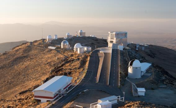
             Based on the surrounding buildings seen in the original I think the tower on which the owl was sitting can be seen sticking up at the end of the left hand road in the attached photo. It can be seen from above here,

    Regards,
    Robin
    File:


    Reply
    Browse Files

    Drop Files

    NavList

    What is NavList?

    Get a NavList ID Code

    Name:
    (please, no nicknames or handles)
    Email:
    Do you want to receive all group messages by email?
    Yes No

    A NavList ID Code guarantees your identity in NavList posts and allows faster posting of messages.

    Retrieve a NavList ID Code

    Enter the email address associated with your NavList messages. Your NavList code will be emailed to you immediately.
    Email:

    Email Settings

    NavList ID Code:

    Custom Index

    Subject:
    Author:
    Start date: (yyyymm dd)
    End date: (yyyymm dd)

    Visit this site
    Visit this site
    Visit this site
    Visit this site
    Visit this site
    Visit this site