NavList:
A Community Devoted to the Preservation and Practice of Celestial Navigation and Other Methods of Traditional Wayfinding
From: Frank Reed
Date: 2017 Dec 22, 09:09 -0800
David, you wrote:
"My first problem is that I’m pretty sure which constellation we’re looking at, but I can’t positively identify all the stars from pictures on the web."
Yes, it's tough because there are no first of even second magnitude stars that I can identify in-frame. Although it's certainly possible to recognize the distinctive pattern of the star clouds in that section of the Milky Way (and, yes, a marine navigator should be able to do this since those star clouds are as useful as the Big Dipper for a quick visual compass), you'll need a good paper star atlas or some sort of "planetarium app", like Stellarium, to identify those fainter stars.
You added:
"When I try to download ‘Stellarium’, my best laptop gives me all sorts of dire warnings and recommends not doing so. Therefore, should I download it anyway, or should I download it onto the less important net-book I use when travelling? Also, should I download the 64bit or 32bit version? I’m running a version of Windows 7, and I'm a digital dinosaur."
The tendency to remain a digital dinosaur is reinforced by hanging out in the NavList community, and it is one of the genuinely negative things about this group. Learning how to understand those messages, going through this process of installing Stellarium, and then learning how to use Stellarium (which does have a little learning curve) is ten times more valuable than fiddling around with spherical trigonometry! Regarding the "dire warnings", you might consider posting those here and asking for clarification. There are others in the same boat as you, so I think it's relevant for the group. Which warnings matter? And which ones are digital "nanny" messages that you can ignore? Next, you asked about 32-bit versus 64-bit. The short answer is that it's not important for an app like Stellarium, so just grab the 32-bit version. What's that all about? Here is a nice discussion. When you get Stellarium installed, play around with it on your own, and then come back with questions, and I will try to deliver a "print" version of my five-minute "Stellarium for Navigators" talk. :)
You concluded:
"My second problem is that I’m sure I’ve seen a method of finding latitude from two simultaneous altitudes and no timing information somewhere, but I’ve looked at all my books and I can’t find it. The net wasn’t much help either. The thing is, am I looking for a simple 2D solution like Mer-Pass, or am I supposed to get into spherical geometry equating two or more spherical triangle with known sides, namely co-alt and co-dec, and a known angle between, namely diff in SHA, to find a common unknown side, co-lat? More hints please."
Yes! That's what makes this an intriguing puzzle. Just how should you go about it? Maybe we could compare multiple methods? One approach is a straight-forward binary search using simulation software. You load up Stellarium with approximately the right sky, and then you just do a higher/lower game (binary search) on the latitude until the displayed altitudes matche the observed altitudes (measured from the image). That's a completely legitimate approach, and an automated system would do something similar. Another approach, which I mentioned earlier and which Gary has emphasized works really well, is to treat this is a common sight reduction plot with some arbitrarily specified longitude and GMT. You'll get two position lines that cross. The longitude where they cross is meaningless, but the latitude is exactly what we require. Note that this also would involve a short binary search iteration if you use any version of the "intercept method" since you'll need to get an AP close to the final fix. Still another approach is to work this up as a modern spherical trig problem --derive some equations yourself for a "closed form" solution, for the fun of it. And finally, this was a very popular problem historically, closely related to the so-called Douwes problem, and there are many historical calculations you could look at in navigation manuals from the nineteenth century. There are many Bowditches and also some Nories and numerous others available in the index I maintain for NavList here:
https://navlist.net/navbooks2.html.
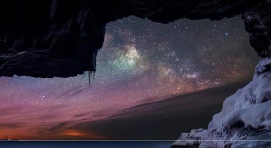
For anyone who didn't see the first post, here are the images again:
Those Milky Way star clouds are quite distinctive! What constellation is at the lower right (mostly behind the clouds). Once you have that figured out, you can identify stars and measure their altitudes in pixels in the image. Then use some star-to-star distance to set a scale from pixels to minutes of arc... 
This version of the image has the horizon highlighted and extended: 
This one identifies three stars you can use. This is a spoiler so look at this image only if you're tired of trying to identify those faint stars! .jpg.thumb.jpg)
You can get your latitude from this photo. But there's no way to get longitude from the stars in a case like this. There's a slim chance you might be able to spot some geostationary satellites in the photo. Could you get your longitude from satellites?
Frank Reed
Clockwork Mapping / ReedNavigation.com
Conanicut Island USA


