NavList:
A Community Devoted to the Preservation and Practice of Celestial Navigation and Other Methods of Traditional Wayfinding
From: Frank Reed
Date: 2024 Feb 13, 19:11 -0800
Dale L.:
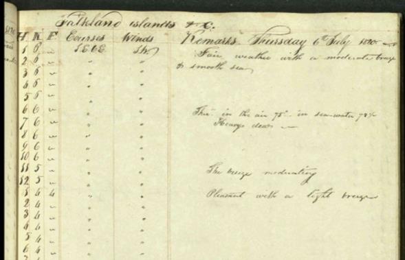
"H K F" is "hours, knots, fathoms". You'll note that this is followed by "courses". So what we have is a record, common in some styles of logbooks 200 or more years ago, of the details intended for the end-of-day dead reckoning calculation. Hours is just time of day, which in that era would have been approximate local Sun time aboard the vessel, often carried forward by sandglass. If the "H" values are strictly hourly, then the values under "knots" and "fathoms" are effectively nautical miles and sixth parts of miles (which you can confirm by noticing that the value under "F" ranges from 1 to 5 (with zero usually implied by a pen stroke, like a dash "—"). The presence of these detailed tables of "H K F" highlight a feature of 18th and early 19th century navigation that, I find, surprises many modern navigators. Back then navigators took their dead reckoning very seriously and believed in its value.
They didn't need to keep a record exactly like this, recording the knots and fathoms each and every hour. That they did so was navigation "culture", a style that they learned. Another style element: quite often you'll find that the H K and F headings are drawn with "hollow" or outline "print" letters rather than the usual flowing script used almost everywhere else. See the example below/attached.
Was there anything else in the headings that puzzled you? The label "Lon in" might be interesting. There doesn't seem to have been any formal definition of the expression in the era when the expression was common. It was the "longitude" that the vessel was "in" --a best estimate longitude, based on d.r. computation primarily.
Frank Reed


