NavList:
A Community Devoted to the Preservation and Practice of Celestial Navigation and Other Methods of Traditional Wayfinding
From: Greg Rudzinski
Date: 2012 Dec 14, 16:23 -0800
Doug,
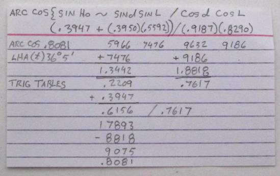
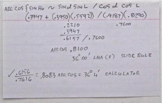
The time sight method sight reduction formula looks to have a user friendly format for calculator crunching. The trig calculator doesn't meet your non electronic requirement but perhaps should be reconsidered if equipped with solar power. The best non electronic time sight reduction as for speed of solution is the slide rule if a small amount of calculation error is acceptable. I did a full trig table solution and found it difficult and error prone. If you are good with trig tables then this may be an option. The Weem's secant time sight table remains to be evaluated. See attached reductions for trig table, slide rule, and calculater compared.
Greg Rudzinski
[NavList] Re: Longitude by Time Sight...good enough at sea?
From: Doug MacPherson
Date: 13 Dec 2012 20:16
Wow, Great discussion. Really appreciate Frank's insight on the Sumner Line and the time sight, also the other great stuff sent my way.
For me, the choice of the time sight and ex-meridian etc. comes down to my parameters for what I want from my navigation "solution".
There are many solutions out there. From the gyro/satellite (electronic) solution I was using as a bridge officer in the USN in the 80's, to the Polynesians navigation system (relying on the sun and stars, winds and clouds, seas and swells, and birds and fish) and everything in between. Choose your parameters and then the solution will follow, i.e. electronic/non electronic, tables/non tables etc.
My current parameters include:
1. Non electronic and based on accurate sextant measurements and an accurate chronometer.
2. As little plotting as possible.
3. As little tedious mathematics (prone to mistakes) as possible.
4. As few books as possible: Norie, Bowditch, Hansen are OK. One book vs. volumes.
5. The best accuracy possible given 1 through 4.
Given all your helpful feedback, my solution would appear to include: Latitude by Polaris, Latitude by Ex-Meridian, Latitude at noon and Longitude by time sight. Books to include, a up to date nautical almanac, Norie's (or Bowditch), Hansen's, and some tables for time sight (Martelli?), (although I am happy with Norie's and the haversine formula's for the time sight). These would appear to be enough.
Certainly, if safety required, the LOP would be utilized (modern methods) .....as well as the handheld GPS :)
Thoughts?
Thanks,
Doug
----------------------------------------------------------------
NavList message boards and member settings: www.fer3.com/NavList
Members may optionally receive posts by email.
To cancel email delivery, send a message to NoMail[at]fer3.com
----------------------------------------------------------------


