NavList:
A Community Devoted to the Preservation and Practice of Celestial Navigation and Other Methods of Traditional Wayfinding
From: Ed Popko
Date: 2018 May 9, 04:39 -0700
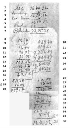
A very nice example. I have never disassembled one of these, Frank has already done it. I have tried to annotate the lines I think I understand marking those I don't or can't read with a question marks.
Below the listing are my speculations as to what this ship might have been doing there.
Bowditch 19th Century Logarithm Method
General
1 Dec of Sun S 16º44’32” might be Nautical Almanac hourly value
2 ?First corr 6’ seems too much for 17 minute increment past the hour
3 ?Exxx xxx 16º 50’32” sum lines 1 and 2
4 ? Corr xxx 4’
5 Second corr 16º 54’32” sum lines 3 and 4
6 Radian 90º
7 Polar Distance 73º 05’28” = 90º - 16º 54’32”
8 ? Sun’s altitude rounded 16º 34’ Lower limb
9 ? altitude correction, possibly dip combined with lower limb 10’
10 Altitude with corrections applied 16º 44’
11 Latitude rounded 24º 03’ (from DR or LAN)
12 Polar Distance rounded down 73º 05’
13 Sum of Altitude, latitude and polar distance 113º 52’ = 16º 44’ + 24º 03’ + 73º 05’
(Sum of lines 10, 11 and 12)
14 Half Sum of line 13 56º 56’ = 113º 52’ / 2
15 Altitude from line 10 16º 44’
16 Remainder = Half Sum – Altitude 40º 12’ = 56º 56’ – 16º 44’
Local Apparent Time to Local Mean Time
17 Local Apparent Time 05:15:18 = 78.8250º = 2 * 39.4125º line 25
18 Equation of Time 00:16:04 (fast)
19 Local Mean Time 04:59:14 = 05:15:18 – 00:16:04
20 Logsec(lat) line 11 03944 = logsec(24º 03’)
21 Logcsc(pDist) line 12 01921 = logcsc(73º 05’)
22 Log Half Sum line 14 9,73689
23 Log Remainder line 16 9,80987
24 Log total 9,80270 = logsec(lat) + logcsc(pDist) + logcos(Half Sum) + logsin(Remainder)
(lines 20 21, 22 23)
25 Logsin(LHA/2) line 24 9,80270 LHA/2 = 39.4125º
Time corrections and conversion to longitude
26 Chronometer time Nautical Day 01:01:00
27 Chronometer rate compensation 00:16:24 slow
28 Chronometer corrected time (lines 26 + 27) 01:17:24
29 Correction of 12hr for Civil Day +12:00:00 hrs
30 Chronometer time Civil Day GMT 13:17:24
31 Local Mean Time line 19 04:59:14
32 Meridian Angle, ‘t’ or longitude as time 08:18:10 = GMT (line30) – LMT (line 19 or 31)
33 Conversion 8 hrs to angle 120º = 08hr * 15
34 Conversion 18 min to angle 04’30” = 18min/60*15
35 Conversion 10 seconds time to angle 02’30”
36 Longitude 124º 32’30” = 120º00’00” + 0º04’30” + 0º02’30” sum of lines 33 to 35
Guano Expedition
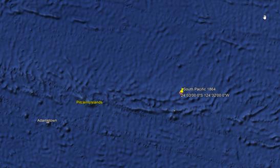
This ship is located just south of the Tropic of Capricorn. Perhaps they were going to or returning from Ducie Island, part of the Pitcairn Islands. A U.S. government expeditionary ship? Commercial guano miners? In 1867, Ducie Island it was claimed by the United States under the Guano Islands Act. Although Captain Edward Edwards discovered the atoll in 1791, Ducie was not considered a British possession.[Wikipedia] In 1867 Ducie was claimed by the United States under the Guano Islands Act, which established that an uninhabited territory with guano deposits could be claimed as a US possession, so long as it was unclaimed by any other country.
Whaling
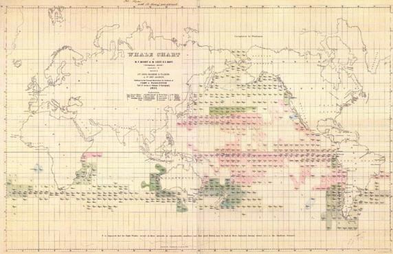
Possible this ship was hunting whales though it’s on the southern most boarder of the “Offshore Grounds”. Below is Matthew Fontaine Maury’s famous 1851 Whale Chart (Source: Washington, D.C., Naval Observatory, 1851. Color lithograph. Geography and Map Division).
Ed Popko


