NavList:
A Community Devoted to the Preservation and Practice of Celestial Navigation and Other Methods of Traditional Wayfinding
From: Frank Reed
Date: 2018 May 7, 22:28 -0700
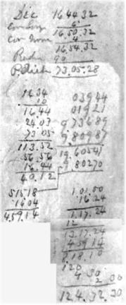
Here's a navigator in the South Pacific working up a longitude on November 9, 1864.
The top part is slightly over-kill: it's the calculation of the "polar distance" --that's just 90+/-Dec. It's not needed to the nearest second of arc, but that was the ritual. Next step: The navigator has taken a sight of the Sun in the late afternoon. The altitude is 16°34'. See that? Then the navigator adds up the (corrected) altitude, the latitude (which is 24°03' S) and the polar distance from the top (which is 73°05'). There's some addition of angles... some logarithms are looked up... but the point of all this is to get to a "sundial time". The sextant has been turned into a sundial... And the result is 5:15:18 in the afternoon. The observed altitude, at a given latitude, implies a local apparent time (a.k.a. sundial time). Next, because the Sun, viewed as a clock, is fast in early November, the Equation of Time gets subtracted off and it's a big correction this time of year (that's 16m04s... see it?). Now we have Local Mean Time and we can compare that with the chronometer. The GMT from the chronometer (after a couple of steps) is 13:17:24. Subtract LMT from GMT and the difference is the longitude as time: 8:18:10. Final step... convert longitude as time to longitude as degrees. And that's easy: every hour is 15° of rotation of the Earth. See the rest??
I haven't spelled out every step here so that there's some "fun" to be had figuring it out. But what we're seeing here is the overwhelmingly popular methodology for working up a longitude in the period from about 1800 to 1945. This was the navigator's daily task for longitude....
This is an actual sight for longitude pulled from a logbook from 1864. The original is barely visible on the page, written in a two-inch space with a light-lead pencil, over 150 years ago.
Frank Reed
Clockwork Mapping / ReedNavigation.com
Conanicut Island USA


