NavList:
A Community Devoted to the Preservation and Practice of Celestial Navigation and Other Methods of Traditional Wayfinding
From: Frank Reed
Date: 2018 May 9, 08:46 -0700
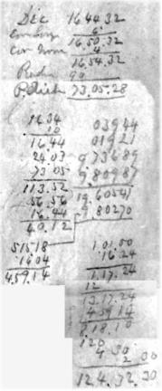
Here's 1864 again:
And now compare with this computation from the whaleship Charles W. Morgan in April of 1897 while whaling near Hokkaido, Japan. Notice how similar it is. It's arranged a little differently, but all the same details are present. In particular, notice that the computation for the declination (and from that the polar distance) is worked to seconds of arc. Why in the world are they doing that? These two calculations, one from 1864, the other from 1897, are separated by 33 years... That's a long time! We have a tendency to think of the 19th century as if it's a couple of decades long (in our minds, history is on a sort of "mentally logarithmic" timescale... the most recent 25 years is one unit of time, the previous 75 years is an equivalent unit, and the 200 years before that is yet another unit), but 33 years is a long stretch of time for such uniformity in practice. Imagine comparing notes between two navigators, one in 1980 and the other in 1947. You would certainly find some common features, but the degree of uniformity in practice we see here from 1864 to 1897 is remarkable, and in fact when we look at "time sights" from another 33 years earlier, they are done in a very similar methodology. Many aspects of "nautical astronomy" (what we call today "celestial navigation") had reached a plateau of stability during the nineteenth century and into the early twentieth.
Frank Reed


