NavList:
A Community Devoted to the Preservation and Practice of Celestial Navigation and Other Methods of Traditional Wayfinding
Re: Low Altitude Sun Artificial Horizon Exercise
From: Bill Ritchie
Date: 2020 Nov 30, 23:03 +0000
From: Bill Ritchie
Date: 2020 Nov 30, 23:03 +0000
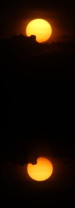
Using the left image only, I calculate 245° / 1.7nm Away (+/- 1.6nm) assuming 50°F / 29.8 InHg. That's a great low altitude result from a great photo. Well done.
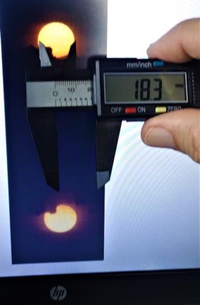
But I'm sure I'm missing your point, Greg - how do the callipers improve this?
Workings.
A: Sun Pixel Diam: 343 +/- 4px
B: UL - UL reflection: 2149 +/- 4px
C: Sun Diam 32.434'
Formula: C * B / A.
Lowest Case Hs: 200.5' = 3° 20.5'
Highest Case Hs = 206.0' = 3° 26.0'
Average Case Hs = 203.2' = 3° 23.2' gives 245° / 1.7nm Away.
Regards
Bill Ritchie. 50N 003W
On Sun, Nov 29, 2020 at 5:32 PM Greg Rudzinski <NoReply_Rudzinski@navlist.net> wrote:
This exercise is to show how a plastic digital caliper can accurately measure any low altitude Sun image using the horizontal diameter as the yard stick.
Image #0759
UT 22:16:31 28 November 2020
Lat. 27° 41.7' N Lon. 80° 23.9' W (GPS)
Diameter of Sun 32.434'
What is the azimuth and intercept from GPS ?
Greg Rudzinski
The image is using a 135mm vintage lens on a Canon 2000D (24MP). Settings: 1/4000sec, ISO 100, f 16. Sun filtered with double polarizers.


