
NavList:
A Community Devoted to the Preservation and Practice of Celestial Navigation and Other Methods of Traditional Wayfinding

Lunars, Occultations: Mountains on the Moon
From: Frank Reed CT
Date: 2005 Mar 2, 20:48 EST

")
From: Frank Reed CT
Date: 2005 Mar 2, 20:48 EST
I've been thinking this evening about tomorrow morning's occulation of
Antares by the Moon and considering again how this might have been useful in
earlier centuries for determining longitude. Since Antares has no measurable
angular diameter of its own, it will blink out almost instantly tomorrow morning
when it is occulted. Its reappearance would be almost as instantaneous. As
people have discussed on this list before (see the Jupiter occultation, back in
December), this observation is like a zero distance "lunar distance"
observation, at least in principle. Without even using a sextant, when that star
disappears, you can say that its lunar distance is 0d 00.0'. But how
accurate is that "zero" observation? For that matter, how accurately could any
lunar distance observation be taken, in principle?
The mountains of the Moon place a fundamental limitation on lunar
distance observations and also occultation timings, historically at least. This
topic has also come up before but I didn't have a source handy at the time to
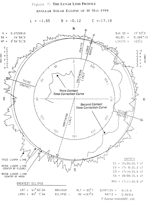
put numbers on the matter. While browsing today, I came upon an old "lunar limb
profile" diagram from the annular eclipse of May, 1994 which was visible
across much of the US. Here's the diagram:
It shows the profile of the mountains and valleys along the Moon's limb at
the time of this eclipse on an exaggerated scale (the profile varies
significantly from one eclipse/occultations to another due to lunar librations).
The scale is on the upper right. Deviations from the perfectly circular form
assumed in lunar distance calculations of 6" or more are fairly common and
typical deviations are around 4". Any lunar distance observation or
occultation-based "zero distance" observation is fundamentally limited at about
this angular scale. And this 4 to 6 arcsecond built-in error translates to
2 to 3 minutes of longitude minimum error. This would seem to be an absolute
limit on all historical lunar longitudes even when all other corrections have
been carefully applied.
Today, the limb profile of the Moon across the full range of libration
angles is relatively well-known and has been for about four decades (hence the
diagram, linked above). Occultation timings today are still valuable because
they refine the limb profiles. They help map the Moon, instead of the
Earth...
-FER
42.0N 87.7W, or 41.4N 72.1W.
www.HistoricalAtlas.com/lunars
42.0N 87.7W, or 41.4N 72.1W.
www.HistoricalAtlas.com/lunars


