
NavList:
A Community Devoted to the Preservation and Practice of Celestial Navigation and Other Methods of Traditional Wayfinding


From: Antoine Couëtte
Date: 2025 Dec 9, 09:57 -0800
Dear Modris,
Thanks for your reply. But ...
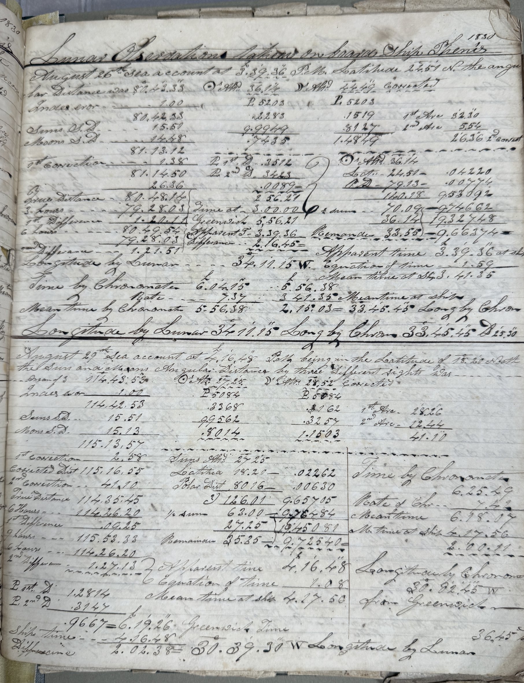
... you are actually answering me that Log(base 10) sin 36°14'= -0.2283 and Log(base 10) sin 44°49' = -0.1519 .
Your mere use of the terms "apparent altitudes" here is not clear at all to me. See why in § (4), second part of this post.
My earlier question - probably not adequately put into some understandable correct form then - does fully remain unanswered. Let me reword it in 2 different ways:
How did the Navigator obtain such "altitude values" from his raw sextant observations ? or in other words :
Which degree of "processing" pertain to such altitudes ?
I already have a partial nonetheless incomplete answer here : both altitudes - i.e. 36°14' and 44°49' - are obviously obtained from sextant readings corrected for at least Index Error and Dip. But :
(1) - Have they been corrected for refraction (yes / no ?) . And :
(2) - Have they afterwards been corrected for Semi-diameter (Yes ? / no ?). And :
(3) - I am not asking any further since I would surmise that here any subsequent Parallax correction is totally ruled out.
If you can simply answer points (1) and (2) here-above as applicable / pertaining to the method actually used by the Navigator, you will simply make my day. I simply need reliable information here. Thanks in advance.
*******
A few necessary add-ons here before the Authority becomes infuriated at such queries:
(4) - I own different reputable Navigation courses in the English language which give different definitions of the "Apparent Altitude" term you are actually using. Which one am I to choose here ? Since in the current context I am unable to reliably choose between two different "reverse-engineering" formulae (should I include SD or not ?) applicable to the Navigator's published altitudes, I am hereby resorting to (1) and (2) hereabove.
(5) - English is NOT my native Language,
This why in view of (4) here-above - and following here an excellent rule pioneered by Paul Hirose on this forum (Thanks to you Paul) - I have most always taken the utmost care in adequately and fully labelling the heights I am dealing with - e.g. "topocentric height" corrected for Dip, + if applicable for Refraction, + if applicable for SD, + if applicable for Parallax (in which case I most often summarize all 4 previous steps into "geocentric heights") - in order to best help whoever wishes to rework my computations on his own.
(6) - By the way, I am familiar with 3 different Lunar solving methods, none of them apparently being immediately comparable to the Bowditch 2 nd method you are referring to. This is why again it is important to me to understand the exact nature of the Navigator's published altitudes.
(7) - Last but not least, instead of taking up too much bandwidth on the NavList forum here - maybe for futile items ? - it has become unfortunate that we can no longer enjoy the former option of directly sending replies to Forum Contributors through e-mails.
My own e-mail address as most often stays quite visible as here-under. Do not hesitate to use it for your upcoming reply. I think it will be best for everybody.
Meanwhile, please accept my very Best Regards, Modris, and thanks for your Kind Attention,
Kermit
antoine.m.couette[at]club-internet.fr


