NavList:
A Community Devoted to the Preservation and Practice of Celestial Navigation and Other Methods of Traditional Wayfinding
From: Frank Reed
Date: 2024 May 19, 20:02 -0700
That's great, Lars. Thank you. A detailed and exacting analysis, as always!
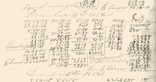
As I said, I didn't get into more than a superficial analysis of this before posting it, but, for others following along, I thought I would mention a key moment in my brief "survey" of this lunar page.
I have learned over the years when facing an unstructured page of calculation like this, that it's useful to come in from the margins. I look at the work near the top, of course, but equally important the far left and far right margins often have key clues (the bottom of the calculation is usually where we find the final result so that's less useful at the beginning). In this case on the right margin, we see a "90 minus" calculation. There are few reasons to do that in the style of these old calculations, but one reason is to get a "polar distance": p.d. = 90° - Dec. For the date in question, that fits. We're looking at a calculation of the Sun's polar distance.
The polar distance is often an input to the well-known and highly standardized computation for local time, which requires computing the brilliantly-named "halfSum". That's half of the sum of the corrected altitude, the latitude, and the polar distance. And sure enough, we see that halfSum work right next to the p.d. calculation. The great thing here is that this tells us the navigator's best estimate of latitude, which is 17° 40'. And it has to be South at this time of year in order to get the Sun at that high altitude. This is also consistent with the calculation of the p.d. since that is always measured from the "nearer pole". Another reason it has to be South. Narrowing down the latitude like this is a useful starting point when analyzing any of these old navigation computations. :)
I'll also note that if they were further out to see this would have been a good latitude to try to spot "Trinidade and Martim Vas", that pair of "rocks" out in the Atlantic off southern Brazil that served so many navigators as they were heading for (or from) Cape Horn. Lunars are nice, but there's no better way to confirm the longitude than by sighting a big, immobile rock with a well-charted position!
Thanks again,
Frank Reed


