NavList:
A Community Devoted to the Preservation and Practice of Celestial Navigation and Other Methods of Traditional Wayfinding
From: David Pike
Date: 2014 Nov 16, 13:31 -0800
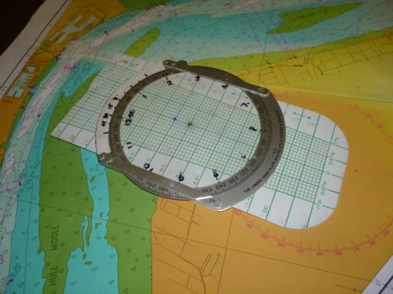
I went to my boat today to see if by chance I’d left my Mear’s Slide on board. When I found it, I remembered what I’d done with it. I’d converted it to a tidal height calculator for a sinusoidal tidal height curve. I’d changed the TASs to heights of tide by painting out the first and last figures. E.g. 470, 480, and 490kts were now 7,8, and 9m. Then I’d divided the front of the computer into twelve 30 degree segments to represent hours. The 30degrees of port drift were now renumbered 15, 30, 45 minutes and one hour. Placing time of high water at the top, placing the mean height under the central dot, and marking the height at high water on the face of the computer allows the height of tide to be read off for up to six hours either side of high water by revolving the computer disc. E.g. in photo. HW 12.31 ht 7.0m, LW 18.56 ht 5.0m mean ht 6.0m. Now all I have to do is work out how to turn it back into a Mear’s slide again. Dave


