NavList:
A Community Devoted to the Preservation and Practice of Celestial Navigation and Other Methods of Traditional Wayfinding
Re: Mercator Sailing and Meridional Parts
From: Gary LaPook
Date: 2014 Dec 2, 03:13 -0800
From: David Pike <NoReply_DavidPike@fer3.com>
To: garylapook@pacbell.net
Sent: Sunday, November 30, 2014 12:31 PM
Subject: [NavList] Mercator Sailing and Meridional Parts
Attached File:

(Mercator-sailing.JPG: Open and save)
From: Gary LaPook
Date: 2014 Dec 2, 03:13 -0800
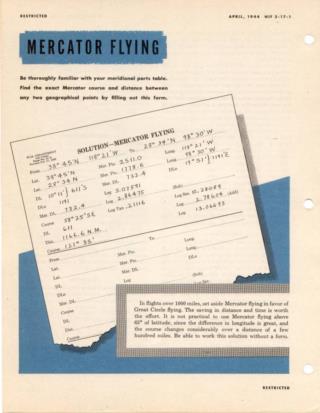
See attached from the 1945 U.S. Army Air Corps navigation manual.
gl
From: David Pike <NoReply_DavidPike@fer3.com>
To: garylapook@pacbell.net
Sent: Sunday, November 30, 2014 12:31 PM
Subject: [NavList] Mercator Sailing and Meridional Parts
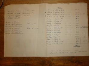
I found a scrap of paper of my fathers today from the 1950s containing a calculation for a course and distance for a sailing between Mukle Flugga and Troena Island (below). Eventually I worked out it must be a Mercator Sailing, which I’d not heard of although I had heard of Plane Sailing. I’d not seen the use of Tabular Logs before either as per NoriesTtables (9. instead of bar one), so that took a bit of getting used to. Having now discovered Meridional Parts, I’m a bit flummoxed to understand why the ones in Nories Tables for the Terrestrial Spheroid come to less than latitude x 60 from 0 degrees to 11.5 degrees before they start racing ahead. Is this because of the compression of 1/293.465 whatever that means?
Attached File:

(Mercator-sailing.JPG: Open and save)


