NavList:
A Community Devoted to the Preservation and Practice of Celestial Navigation and Other Methods of Traditional Wayfinding
Re: Mercator Sailing and Meridional Parts
From: Stan K
Date: 2014 Nov 30, 16:01 -0500
From: Stan K
Date: 2014 Nov 30, 16:01 -0500
FYI, the "The Sailings" tool of Celestial Tools does Course and Distance, Destination L and Lo, and Set and Drift using Mercator Sailing, as well as with Mid-Latitude Sailing and something I call Accurate Rhumb Line Sailing (for lack of the real name). When using Mercator Sailing it also shows the values of the meridional parts and their difference.
(It also does Initial Course and Distance and Destination L and Lo using Great Circle Sailing.)
Stan
-----Original Message-----
From: David Pike <NoReply_DavidPike@fer3.com>
To: slk1000 <slk1000@aol.com>
Sent: Sun, Nov 30, 2014 3:32 pm
Subject: [NavList] Mercator Sailing and Meridional Parts
Attached File:

(Mercator-sailing.JPG: Open and save)
From: David Pike <NoReply_DavidPike@fer3.com>
To: slk1000 <slk1000@aol.com>
Sent: Sun, Nov 30, 2014 3:32 pm
Subject: [NavList] Mercator Sailing and Meridional Parts
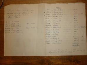
I found a scrap of paper of my fathers today from the 1950s containing a calculation for a course and distance for a sailing between Mukle Flugga and Troena Island (below). Eventually I worked out it must be a Mercator Sailing, which I’d not heard of although I had heard of Plane Sailing. I’d not seen the use of Tabular Logs before either as per NoriesTtables (9. instead of bar one), so that took a bit of getting used to. Having now discovered Meridional Parts, I’m a bit flummoxed to understand why the ones in Nories Tables for the Terrestrial Spheroid come to less than latitude x 60 from 0 degrees to 11.5 degrees before they start racing ahead. Is this because of the compression of 1/293.465 whatever that means?
Attached File:

(Mercator-sailing.JPG: Open and save)


