NavList:
A Community Devoted to the Preservation and Practice of Celestial Navigation and Other Methods of Traditional Wayfinding
From: Frank Reed
Date: 2021 Jun 25, 12:06 -0700
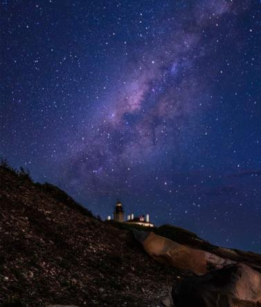
Two challenges with this photo (if you dare!):
- What is the approximate latitude of the photographer based on the stars?
- What is the approximate date based on the stars?
Note that the lighthouse in the foreground is Beavertail Lighthouse which is 2.5 nautical miles from where I live. The view of the lighthouse is from the west side of the point looking towards the south or up to 15° east of south (you can assume the azimuth of the lighthouse tower in the image is 170° true). We are looking "up" somewhat. The angular altitude of the lighthouse beacon is approximately 10° above the true horizon from the photographer's position. Of course, you could look up the latitude of the lighthouse. Problem solved! But not quite. The sky tells a different story.
I have often said that when learning the constellations, the faint stars can be key guides --like the equilateral triangle and attached parallelogram of fainter stars hanging off Vega. In this image, Corona Australis leaped out at me. Find that and then look for bright constellations and navigational stars.
Frank Reed
PS: Unlike some challenges which I post without knowing whether there is any answer, in this case I do have a pretty good idea what you should find.


