NavList:
A Community Devoted to the Preservation and Practice of Celestial Navigation and Other Methods of Traditional Wayfinding
Re: Milky Way photo navigation challenge
From: Robin Stuart
Date: 2021 Jun 28, 11:49 -0700
From: Robin Stuart
Date: 2021 Jun 28, 11:49 -0700
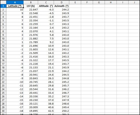
I was hoping to be able to put this down but it was not to be. Measuring the zenith-ε Scorpii-Antares angle at 111° and with a bit of coding in Mathematica it's possible determine when that angle is reached as a function of latitude and LST. The altitude and azimuth of Antares at the time can then be computed. I've tabulated the results in the attached spreadsheet. Simulating some of the numbers in Stellarium indicates that the values seem to be correct. To me 0° latitude is pretty is a pretty good fit with Antares about 11° above the horizon at the time. Maybe it was taken from the Galapagos Islands. It might be something that an enthusiastic vacationer would try to capture,
Robin Stuart


