NavList:
A Community Devoted to the Preservation and Practice of Celestial Navigation and Other Methods of Traditional Wayfinding
From: Bill Ritchie
Date: 2021 Oct 21, 19:01 +0100
Nice problem, Frank.
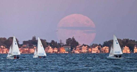
I suggest the UT of the photograph was 21:57:26 and estimate the accuracy to be :
a) Vagaries of refraction: +/- 1 minute. (But image looks normal, so probably +/- 20 secs.)
b) Pixel measurement of Moon diameter: +/- 5px = +/- 1’ arc = +/- 6 secs.
c) Range measurement: +3px = Dip short 2.8nm (i/o 3.8 nm) = -0.5’ Hs correction = - 3 secs.
My reasoning follows.
Regards,
Bill Ritchie
50N 003W
Pixel scale:
Moon (horizontal) Diam. Left x = 237, Right x =409. Diameter = 172px. (Pixels depend on zoom)
Moon SD (0 Aug) = 15.0’. Diameter = 30.0’
1 px = 30.0 / 172 = 0.174’.
Shoreline:
Typical US domestic floor to floor height = 9ft = 8px. (I used balconies)
1ft at shoreline = 0.89px = .155’.
1ft at 3600ft subtends 1’. Thus shoreline = 3600 / .155 = 23225ft = 3.8nm.
Moon UL Hs measured from shoreline:
UL y = 59. Shore y = 227. Hs Moon UL = 168px * 0.174 = 0° 29.2’.
Correct Hs for dip short:
17ft HoE dip short for 3.8nm. Reduce Hs by 0.1’. Hs = 0° 29.1’.
(True horizon 4.8nm)
Altitude Corrections.
Dip -4.0’, Standard Refr -29.6’, SD -15.0’, Parallax + 55.3’. Total +6.6’.
Ho Moon = 0° 35.7’.
Find UT for Ho = 0° 35.7’:
21:57:26.
Gross error check:
Astron gives Lower Limb Moonrise at this position for 17’ HoE at 17:57:01 local time. (GMT – 4)
How about something relatively simple and directly navigational... Let's assume the observer's latitude and longitude are 41°18.4' N and 72°04.6' W. The local date is 19 October 2021. The sea horizon is visible in the photo (in front of that background of land and houses). The Moon's side-to-side diameter gives us an angular scale. From that we can measure the altitude of the Moon's Upper Limb. So figure out when the sight was taken! What is the UT? How accurate can you be? You can assume a height of eye of 17 feet or so. Go here for basic almanac data if you need it: Clockwork Mapping USNO web app clone (preset).
Frank Reed


