NavList:
A Community Devoted to the Preservation and Practice of Celestial Navigation and Other Methods of Traditional Wayfinding
From: Frank Reed
Date: 2024 Jun 16, 07:17 -0700
Hello, Martin.
From your lunar observation (and the included altitudes), I have deduced your "exact" position, accurate to within about 100 feet or 30 meters, I would say. I find:
34°33'25"S, 58°24'35"W.
I do believe that's close. Here's a view from there complete with lamppost, railing, people fishing, and a vessel in the distance, just as in your photo. Amazing that one can get such accuracy from lunar observations, isn't it?! Nearly GPS accuracy ...from a lunar!!
Heh. :)
Actually, of course, the celestial data gets me no better than a confirmation that you are on the shore of the River Plate estuary somewhere in Buenos Aires. To get the "exact" position I provided above, I followed a simple algorithm:
- Your photo shows a unique and unusual lamppost suggesting a park that has some honorary significance.
- We know that you are a pilot, and I considered it likely that you would have preferred observing locations near an airport.
- Starting near the airport, I bounced around in Google Street View along the shore until I spotted that style of lamppost.
My algorithm seems to have worked, though it's possible it's a false match.
Getting back to your lunar observation, I noticed a couple of things. First, you don't need the altitudes of the Sun and Moon to a tenth of a minute of arc. The nearest minute of arc is more than enough. Also, I noticed that your altitudes had average times one full minute earlier than the time for your lunar distance itself. Was this a "typo" or was it actually the case?
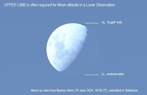
Your Moon altitude is listed as, and consistent with, a "Lower Limb" observation. Did you get that altitude by observation or from an app? Either option is just fine for modern experiments with lunar distances, and even historically altitudes for lunars were sometimes calculated from a DR position (not a great idea historically, but they did so sometimes). The catch here is that a sextant observation of the Moon's Lower Limb at this time would have been nearly impossible. The LL is dark. We can even see in your photo that the UL is the bright limb, and that's clear in simulation, too (see image). Of course you might have estimated where you believed the LL to be "by eyeball" and that, too, would work. I'm just curious what you actually chose to do here.
Did you clear this lunar using my web app [set up for this lunar here] or some other method? One advantage of using an app / software analysis (my web app or anything similar that you might construct --you had mentioned generating your own spreadsheet) is that you can experiment with the inputs to test sensitivities to exact values. For example, if you adjust the index correction by a tenth a minute of arc, it impacts your final outcome (the error in the lunar) by that same tenth of a minute, and every additional tenth of a minute one-to-one. That's no surprise, but it's worth remembering. A well-determined index error/correction is essential here.
You can test sensitivity to other parameters, too. If you bump the observed altitudes by two or three minutes of arc, you should find no significant change in the outcome. Similarly, if you try moderately different temperatures and pressures, no real change. And does the oblateness of the Earth matter in this case? You can try clicking the "ignore" box to test that. By experimenting like this, you can find out: which inputs matter... which inputs are less important.
Frank Reed
Clockwork Mapping / ReedNavigation.com
Conanicut Island USA


