NavList:
A Community Devoted to the Preservation and Practice of Celestial Navigation and Other Methods of Traditional Wayfinding
From: Frank Reed
Date: 2023 Apr 3, 16:13 -0700
That's great, Art. Thanks for posting your data. I did a quick analysis that, I think, has some clues in it. I want to post the result now, and then we can talk more about it in later posts.
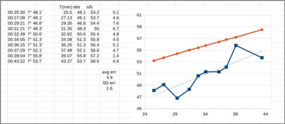
I've inclunded an image capture from my spreadsheet analysis. One column shows the time in minutes (decimalized). That's what I've used for the horizontal axis in the graph. The next column "obs" shows the minutes above 7° for your sights as observed. The column after that "s/b" shows what "should be" --the minutes over 7° that you should have found from your location if everything worked perfectly (*). The next column is the difference, "observed"-"should be". And then below that I've let the spreadsheet calculate the average error and the standard deviation error. Certainly the most interesting thing here is that your observed angles are clearly too big and by an amount that would be very hard to miss: roughly five minutes of arc. Anyone have any ideas? I have a few thoughts, but it's just after sunset here and the chickens and ducks and cats and dog require my attention for a while. :)
Frank Reed
Clockwork Mapping / ReedNavigation.com
Conanicut Island USA
* The "should be" values are found by fiddling with my web app until the error for the required time is zero (less than +/-0.05').


