NavList:
A Community Devoted to the Preservation and Practice of Celestial Navigation and Other Methods of Traditional Wayfinding
From: Frank Reed
Date: 2015 May 9, 12:01 -0700
Bill B, you wrote:
"I was referring to keeping longitude lines equally spaced, and using Bowditch Table 6 (was Table 5?) Meridional Parts to arrive at the spacing of the parallels. My reference is "Practical Celestial Navigation," by Susan P. Howell"
I don't use or teach from Howell's book for two reasons: first and foremost, it's "70s style navigation". If I want historical navigation methods, why would I go back to the disco era?? Second, the book was never really published. It was printed, yes, many times... but it never saw a proper editing, and of course, since Sue Howell was lost at sea, her second edition never appeared. A second edition would supposedly have included more calculator methods prominently in the core of the book. The "construct your own Mercator chart" chapter strikes me as an add-on. It serves no purpose in the book, and you'll notice that no practical advice is offered on how a navigator might benefit from it. The only explanation offered is erroneous, 'that most commercially available plotting sheets are Mercator projections' (with the implication that constructing your own by the rules of the chapter saves money). Commercial plotting sheets and their government-issue equivalents are usually only locally conformal, not Mercator projections. For the construction details, since that method is taken, slightly modified, from any edition of Bowditch from 1958 to 1984, you can reference the "American Practical Navigator" instead of Sue Howell's book.
Back to your original point, yes, that DIY Mercator goes beyond the longitude-scaled plotting sheet, and it is a real, do-it-yourself Mercator projection. The algorithm provided in Bowditch is convoluted and arcane (there's a much easier way to do the math and set the scales with no special table required), but setting that aside, when you are done, what do you have? Well, you have an unmarked Mercator chartlet of a small part of the world. This has little or no value to you as a practical navigator. Why would you want it? Is there some advantage to rolling out a large sheet of paper and plotting all over it that beats using three or four small, convenient plotting sheets? Tell me, Bill or anyone else, why do you personally think you need a Mercator chart? It's not a trick question. I'm just curious what you think you would get from one. Can anyone suggest an important reason for using an actual Mercator chart for celestial navigation? And what are the disadvantages of a Mercator projection (hint: Greenland)?
You asked:
"If there is a question in there, is her method a "bad habit?" "
Yes, it is. Absolutely. But it's a different bad habit from the habit of calling a common plotting sheet a Mercator chart (which is a really bad habit). No one needs a homemade regional Mercator chart like this, at least as far as I can see, and perhaps that's why this technique appeared in editions of Bowditch only from 1958 through 1984 (arguably, that's ONE edition of Bowditch with incremental changes during the period). I suspect this method appealed to some specific individual on the editorial team at the H.O. in the mid-1950s. It made someone happy, so they included it in 1958. It was dropped without fanfare three decades later (at least I think it was... it may be hidden in there somewhere in a more recent edition!)
Regarding the section in Sue Howell's book, you wrote:
"I am guessing scanning the relevant pages and posting on NavList would be copyright infringement."
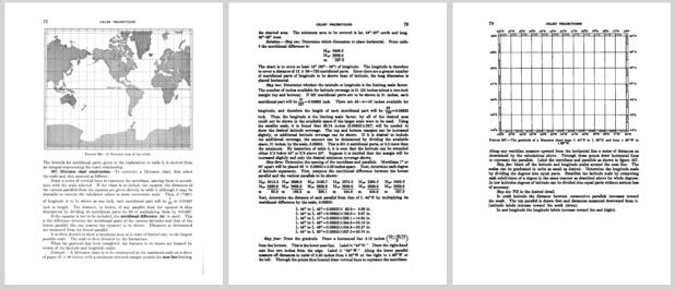
We can bypass that problem. I'm attaching here the relevant pages from Bowditch. This text and its included example did not change from 1958 until it was dropped after the 1984 edition.
You PSed:
"Along with lofty title of "Head cartographer, Centennia Historical Atlas, HistoricalAtlas.com" do you also hold the title of "Garbage and Trash Removal" shared by many other small business owners? Or did you write that out of your job description when you were writing it? "
I do take out the trash. My assistant, Steph, could do it, but I don't mind taking out trash. My "lofty title" of head cartographer is accurate, and it was intended to be funny for those of you who have "known" me for years (even if only online), but there are plenty of people who are new to the NavList community in the past few years who have no idea that I am a professional map-maker (in the real world, I prefer introducing myself as a "map-maker" since the word cartographer is a bit of a puzzler for many people). And when I speak about map projections, I know what I am talking about.
Frank Reed
Conanicut Island USA


