NavList:
A Community Devoted to the Preservation and Practice of Celestial Navigation and Other Methods of Traditional Wayfinding
From: Bob Goethe
Date: 2015 May 6, 10:20 -0700
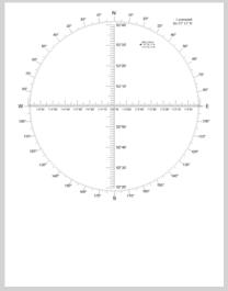
I am attaching a PDF of a plotting sheet I have optimized for the area where I take practice sights. If you have a vector drawing program (like CorelDraw or Adobe Illustrator) you can create a mercator plotting sheet...and you can choose any latitude you want to define the width of a degree of longitude. In this case, I chose 53° 15' as the latitude that would define the width of a degree of longitude.
(Plotting the location of my home right on the sheet lets me evaluate, at a glance, the accuracy of my sextant sight.)
I have considered reconstructing this sheet assuming a latitude of 53° 30', to optimize it for the location of my house...which is where I most often take sights from.
To be honest, though, I have discovered that optimizing your sheet for 53° 00' or 54° 00' doesn't make much of a difference in plotting. The width of the pencil lead that I use is wide enough that is just doesn't pay to get too anal about the width of a degree of longitude.
I have not experimented to determine the point at which I need to create different mercator sheets for plotting. My hunch is that if you are near the equator, one plotting sheet is probably useful at plus-or-minus 5° of latitude. As you move further away from the equator, the need grows for different mercator sheets to ensure accurate plotting.
Bob


