NavList:
A Community Devoted to the Preservation and Practice of Celestial Navigation and Other Methods of Traditional Wayfinding
From: Frank Reed
Date: 2019 Oct 27, 09:22 -0700
File:
Nice.
It's M.O.O.! ...or Motion Of the Observer.
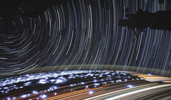
A fixed observer has to wait something like 80 minutes to get star trails as long as these, about 20° in length, measured in hour angle from the pole. But if you're zipping along at 17000 mph (and we are since this is a view looking out the window from aboard the ISS), then the stars will trail 20° in just about five minutes. The sky rotates about a fixed axis perpendicular to the velocity vector as the observer rolls along.
This is the effect of MOO for surface observers, too. If you're sailing southeast, for example, then in addition to any diurnal (normal, daily) movement of the stars, the stars directly off your bow are rising at a rate in minutes of arc equal to your speed in knots, while those directly astern are sinking at the same rate, and stars abeam, to port and starboard, are rotating around "poles" located on your horizon. And if your course is southeast, then those poles are on the horizon on an axis running NE/SW. The celestial sphere rotates about that axis as you travel southeast.
That fixed "pole" visible in the photo, about which the celestial sphere seems to be rotating, is on the port beam for the station's motion, and it is located nearly on the true horizon (in the sense that it is 90° away from the vector that points to the Earth's center). At this altitude (412 km or so), the dip of the ground horizon is about 20°, while the dip to the air glow horizon (the oxygen-green fuzzy horizon) is about 17.5°, which is all consistent with what we see.
Each star trail is divided up into numerous little "blips". The trails of city lights on the ground are more obviously divided. It's difficult to count with any accuracy, but it appears to me that there are about 300 dots on each star trail. That's consistent with a five-minute time-lapse exposure in which the camera was "open" for one-half of each second.
The nebulous white flashes extending toward the horizon are presumably lightning flashes in thunderstorms beneath the station. These flashes seem to be repeating along lanes in the image, and some of the flashes have similar shapes at different times. That makes sense if the lightning flashes are occurring at typical intervals of two to five seconds in each storm cloud. As the station flies to the right (in the image), the apparent positions of the storm clouds drift steadily to the left, each in its own traffic lane.
Notice that some of the star trails have little hooks at the lower ends when they reach the horizon. This appears to be the effect of atmospheric refraction. From orbital altitudes, there is essentially zero refraction except within a very narrow band approximately equal to the height of the troposphere which is about half a degree at that height.
I can't figure out the stars here. What constellations are we looking at? It's always difficult when you're looking at star trails. Also notice that there are some satellite trails in the image. With some some fairly hard work, it would probably be possible to work out the exact time and location of the image and then figure out which satellites are in view, too. Maybe another time! :)
Frank Reed


