NavList:
A Community Devoted to the Preservation and Practice of Celestial Navigation and Other Methods of Traditional Wayfinding
Re: NOW what?
From: Gary LaPook
Date: 2015 Aug 19, 07:54 +0000
From: Frank Reed <NoReply_FrankReed@navlist.net>
To: garylapook@pacbell.net
Sent: Tuesday, August 18, 2015 10:57 PM
Subject: [NavList] Re: NOW what?
From: Gary LaPook
Date: 2015 Aug 19, 07:54 +0000
I am trying to get my head around this discussion. I can see that if you are taking a "time sight" on a body on the prime vertical to your east and the horizon to the east is depressed downward since you are on a little gravity hill (deflection of the vertical due to gravity) then the longitude will be shifted by the deflection of the vertical in the east-west direction. But, I though that the observatory at Greenwich used a telescope mounted so that it pointed south along the meridian with the axis (trunnions) aligned east west and level (but not actually level if the vertical is deflected in the east--west direction) so the deflection of the vertical in the east-west direction wouldn't affect sights taken straight south on bodies as they cross the meridian at a zero elevation then no amount of deflection of the vertical in the east-west direction will affect the measured time.
If you then deflect the telescope upwards to measure the time when another star crosses the meridian then the telescope will not be aligned any more with the meridian but will have moved off slightly to the side if the vertical is deflected in the east-west direction. (In tank gunnery we call this "trunnion cant", we elevate the gun barrel but it doesn't move straight up, it moves slightly sideways and the computer makes an adjustment for this.) So it would appear that the time measured form higher altitude stars would be different than the time measured from low altitude stars and that the astronomers would have noticed this problem. I suppose that if the star catalog had been prepared at that same site then the assigned R.A.s for the other bodies would have the same displacement so that the times would still work out all right. But the problem witll appear if using a star catalog prepared at a different site with a different vertical.
Does this make sense?
gl
From: Frank Reed <NoReply_FrankReed@navlist.net>
To: garylapook@pacbell.net
Sent: Tuesday, August 18, 2015 10:57 PM
Subject: [NavList] Re: NOW what?
Don Seltzer, you wrote:
"I am confused by 'true prime meridian'. The PM is completely arbitrary..."
"I am confused by 'true prime meridian'. The PM is completely arbitrary..."
I tried to emphasize the difference in my last post, but obviously I'll have to try some more! An astronomically determined line of longitude (or latitude) has wobbles in it. It snakes back and forth across the globe. Never mind the number placed next to it identifying it as a specific longitude. This doesn't have to be the Greenwich meridian, and we could even consider this in a world with multiple "prime" meridians. Any of those meridians astronomically determined will be "wobbly" on the ground thanks to the small variations in the local vertical. These astronomically-determined coordinates are not "true" coordinates because calculations with those coordinates cannot yield accurate distances between points
I'm sure you understand what it means when I say that the vertical is tilted to the west by 40 seconds of arc for observers a dozen miles west of Bermuda and tilted 40 seconds of arc east for observers a dozen (-ish) miles east of Bermuda? But I ask you: tilted relative to what??
Don, you added:
"The new PM 100 meters east of the 19th century line is a mathematical convenience determined in the 1980's to minimize the errors as observed at different locations around the world."
"The new PM 100 meters east of the 19th century line is a mathematical convenience determined in the 1980's to minimize the errors as observed at different locations around the world."
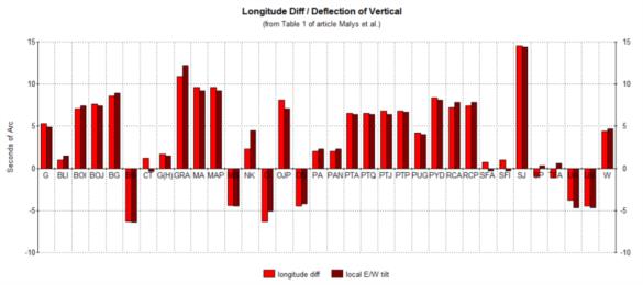
Uh, says who?? I quoted a story something like that for a few years but I don't know where it originated. Turns out it was wrong. And if that were really the case then it's one helluva coincidence that the local east-west tilt of the vertical at those locations you're referring to just happens to be equal to the difference in longitude between the astronomically determined longitudes and the geodetic (TRUE) longitudes. Do you see that there is a very nice match between those in the table in the article? Here's my barchart version again:

In this barchart, each pair of bars represents one observing station. The lighter red bar indicates the difference between the astronomical and the geodetic longitude (in other words, GPS longitude ...but it could just as easily have come from precision ground surveys).

In this barchart, each pair of bars represents one observing station. The lighter red bar indicates the difference between the astronomical and the geodetic longitude (in other words, GPS longitude ...but it could just as easily have come from precision ground surveys).
Frank Reed


