Welcome to the NavList Message Boards.

NavList:

A Community Devoted to the Preservation and Practice of Celestial Navigation and Other Methods of Traditional Wayfinding

Compose Your Message

Message:αβγ
Message:abc
Add Images & Files
    Name or NavList Code:
    Email:
       
    Reply
    Re: NOW what?
    From: Don Seltzer
    Date: 2015 Aug 19, 08:33 -0400
    In the 19th century an arbitrary decision was made to declare that the PM passed through Greenwich for political and economic reasons.  The exact location was set by the siting of a transit from which various astronomical observations were made.  Similar observations were made around the world to determine relative longitude with respect to that site in Greenwich.

    My understanding is that in the 20th century it became possible to measure the actual distances between locations using the time delay of radio signals.  It became apparent that were small errors in the celestial navigation measurements, and these could largely be attributed to gravitational variations which affected the true vertical at these locations.

    In 1984, a new mathematical model called WGS84 was adopted.  Part of the model was the shifting of the PM about 100 meters east of the old PM.  It seems to me that there were other options. The PM could have been left as originally defined and all other longitudes shifted accordingly. Or some other spot on earth could have been found where gravity was such that a true vertical was obtained, declaring it to be the 'new' Greenwich.  Of course this would have been tremendously disruptive.  The option chosen created the least disruption to existing maps as viewed world wide.

    Newspaper accounts suggest that original observatory was in the 'wrong' location, and the true location should have been near a rubbish bin 100 meters east.  But suppose Airy had in fact set up his transit near that rubbish bin in the 19th century.  All of the world's CN observations would still have the same errors, and WGS 84 would recommend yet another true PM another 100 meters east, perhaps in some car park. The new PM is just as arbitrary as the former.

    Don Seltzer

    Sent from my iPad

    On Aug 19, 2015, at 1:57 AM, Frank Reed <NoReply_FrankReed@fer3.com> wrote:

    Don Seltzer, you wrote: 
    "I am confused by 'true prime meridian'. The PM is completely arbitrary..."

    I tried to emphasize the difference in my last post, but obviously I'll have to try some more! An astronomically determined line of longitude (or latitude) has wobbles in it. It snakes back and forth across the globe. Never mind the number placed next to it identifying it as a specific longitude. This doesn't have to be the Greenwich meridian, and we could even consider this in a world with multiple "prime" meridians. Any of those meridians astronomically determined will be "wobbly" on the ground thanks to the small variations in the local vertical. These astronomically-determined coordinates are not "true" coordinates because calculations with those coordinates cannot yield accurate distances between points

    I'm sure you understand what it means when I say that the vertical is tilted to the west by 40 seconds of arc for observers a dozen miles west of Bermuda and tilted 40 seconds of arc east for observers a dozen (-ish) miles east of Bermuda? But I ask you: tilted relative to what??

    Don, you added:
    "The new PM 100 meters east of the 19th century line is a mathematical convenience determined in the 1980's to minimize the errors as observed at different locations around the world."

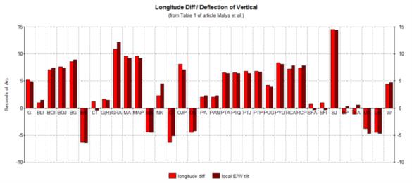
    Uh, says who?? I quoted a story something like that for a few years but I don't know where it originated. Turns out it was wrong. And if that were really the case then it's one helluva coincidence that the local east-west tilt of the vertical at those locations you're referring to just happens to be equal to the difference in longitude between the astronomically determined longitudes and the geodetic (TRUE) longitudes. Do you see that there is a very nice match between those in the table in the article? Here's my barchart version again:

    In this barchart, each pair of bars represents one observing station. The lighter red bar indicates the difference between the astronomical and the geodetic longitude (in other words, GPS longitude ...but it could just as easily have come from precision ground surveys). 

    Frank Reed


    Reply
    Browse Files

    Drop Files

    NavList

    What is NavList?

    Get a NavList ID Code

    Name:
    (please, no nicknames or handles)
    Email:
    Do you want to receive all group messages by email?
    Yes No

    A NavList ID Code guarantees your identity in NavList posts and allows faster posting of messages.

    Retrieve a NavList ID Code

    Enter the email address associated with your NavList messages. Your NavList code will be emailed to you immediately.
    Email:

    Email Settings

    NavList ID Code:

    Custom Index

    Subject:
    Author:
    Start date: (yyyymm dd)
    End date: (yyyymm dd)

    Visit this site
    Visit this site
    Visit this site
    Visit this site
    Visit this site
    Visit this site