NavList:
A Community Devoted to the Preservation and Practice of Celestial Navigation and Other Methods of Traditional Wayfinding
From: Frank Reed
Date: 2023 Jul 2, 20:49 -0700
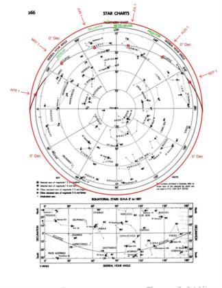
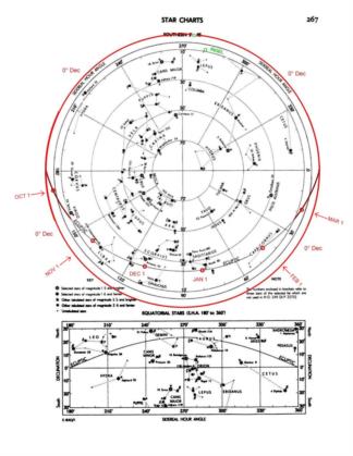
There are star charts in every modern edition of the Nautical Almanac. If we sketch overlays for our latitude, we can use them to make a rough-and-ready star finder that's plenty good enough for sight planning. I'll start off in this post with "Step One" which consists of additions you can make to those star charts, either directly in the pages of your own recent edition almanac or on a printed copy of a scan.
STEP ONE INSTRUCTIONS:
- Ignore the equatorial charts and use the polar charts. They provide nearly complete coverage of the entire sky.
- You can extend the coverage to cover the entire sky by adding an outer circle to each for 0° Dec.
Note that the printed Dec circles are separated by 20° ranging from 90° down to 10°.
This means the additional outer circle is only slightly larger than the 10° circle. - Sketch in extensions to the ecliptic on each (N/S) chart so that they extend down to the equinox points at Dec=0°, SHA=0°/180°.
- Add the bright stars with Dec near zero: Betelgeuse, Rigel, and Procyon. There are a few others that I would count as optional.
- Mark the Sun's position for the first of each month along the ecliptic and add labels around the outer circle of the chart.
Images below (attached) show marked-up versions of the Nautical Almanac pages. Of course, you can just use these directly for now, but the idea is that you should be able to reproduce this from any old (less than 65 years old) copy of the real Nautical Almanac.
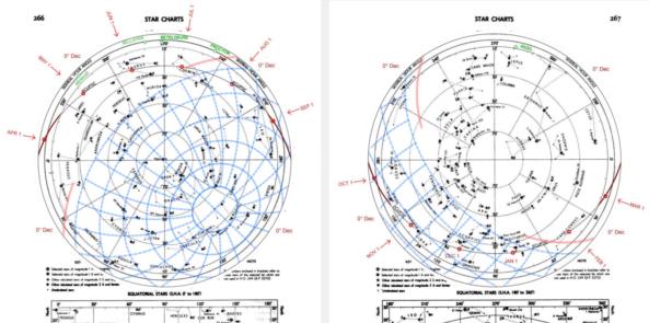
Coming up next: how to sketch (or print) overlays specific to your latitude with twilight bands for alignment. As a preview of things to come, I'm also including an image with overlays gridded every 15° of altitude and azimuth set up for latitude 41°N (my latitude) showing the beginning of nautical twilight for tomorrow, July 3. Does it match your expectation and/or calculations?
Frank Reed
Clockwork Mapping / ReedNavigation.com
Conanicut Island USA


