NavList:
A Community Devoted to the Preservation and Practice of Celestial Navigation and Other Methods of Traditional Wayfinding
From: Frank Reed
Date: 2023 Jul 3, 20:35 -0700
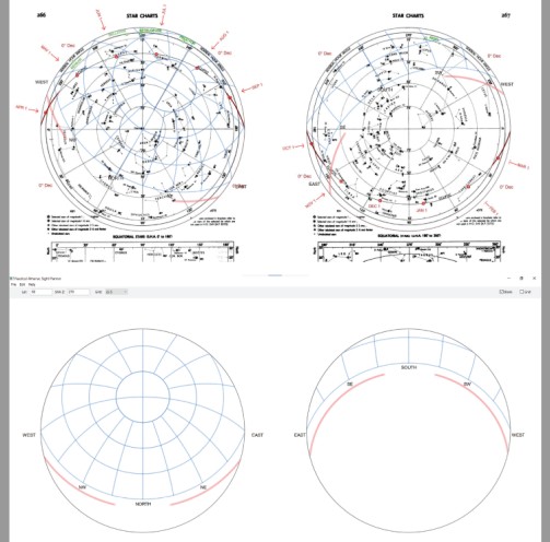
For today, I'm adding sample altitude/azimuth overlays for a few latitudes. The intention behind this "homemade starfinder" is not that you would carry around a set of pre-printed overlays for every 10° of latitude or something similar, but that you would sketch your own overlay based on some basic astronomical principles. Can you see how to use it?
Let's start with a relatively easy case. Suppose your latitude is 40°N. Grab a transparency sheet (hard to find today and often expensive) or a sheet of "tracing paper" (I bet you have a pad collecting dust somewhere!) or a thin sheet of copier paper. Trace the 40° overlay grid onto that page. Place it over the base map, and pin it with a thumbtack through the center. You'll rotate this around the center until the zenith of the overlay falls on the appropriate SHA line for the date and time you're trying to simulate. You can do this by calculation using various methods (SHA Zenith = 360°-LHA Aries so if you know how to get LHA Aries, you're all set). You can also get the same alignment by placing the Sun at the right altitude and/or azimuth for a particular time of night. For evening twlight, rotate the overlay until the west branch of the red/pink twilight band falls on the Sun's position for today. Match the SHA Zenith on the "other hemisphere" star chart, too. Now you can directly read off the altitudes and azimuths of your favorite stars with an accuracy of better than +/-5° --plenty good enough for sight planning.
You can sketch your own overlay grid for any latitude you choose. Suppose you need a latitude of 34°N. That will be the declination of the zenith. Next the horizon under Polaris will have a declination of 90-34 or 56°N. The meridian horizon on the southern sky chart will have a declination of 56°S. Copy the general pattern from the standard overlay with the nearest latitude. Your sketched overlay specific to your latitude should be visually intermediate between the overlays for 40°N and 20°N.
Frank Reed


