NavList:
A Community Devoted to the Preservation and Practice of Celestial Navigation and Other Methods of Traditional Wayfinding
From: Frank Reed
Date: 2022 Aug 25, 20:29 -0700
I've been driving to the Jersey Shore frequently this summer to run stargazing cruises. I often see the New York City skyline as I drive (depending on the route Google selects), and I have found the city strangely unrecognizable thanks to a significant number of new skyscrapers that have been completed in the past decade. Some of them are called supertalls (as a noun) and pencil towers because some are so thin relative to their heights. There's the famous recovery in southern Manhattan surrounding One World Trade Center, of course. There are some odd towers out there, like the Brooklyn Tower. But most of the action is in the vast Hudson Yards re-development and in so-called Billionaires' Row, which consists of an extraordinay chain of supertalls reaching for the stratosphere, both in height and price, casting long shadows across Central Park.
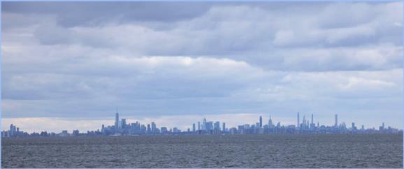
I've been learning the new "constellation" of the city, and I realized I could make a nice navigation problem out of it. I'm including three images (not mine -- "borrowed"). The first, with the ominous clouds is just to highlight the new skyline. Look for the Empire State Building in there; it's almost lost among the new buildings. The second and third images constitute the navigation puzzle. And this is a basic, traditional navigation problem. Determine your location from the alignment of structures and buildings in the photo. It's highly "zoomed", like a view through a telescope, so there's significant "telephoto compression" of distance. The first version of the photo is "clean". The second includes an angular scale and also labels above some of the towers. All three of these photos are views from generally south of the city. There are many skyline photos from this direction recently thanks to another remarkable change in this area: whale-watching is a booming business. In fact, the boat we hire for stargazing at night runs fishing cruises in the mornings and whale-watching every afternoon. Humpback whales and large pods of dolphins are now regular sights off New Jersey and New York City.
So can you solve this one without cheating (*)? Where was the photographer (in the second/third photos)? How confident can you be in the position? Can you use Lunars to find your position?? Well, no. But maybe you could use Luna. There might be a race here to get the best position, but there are no obstacles. It's no Steeplechase.
Frank Reed
Clockwork Mapping / ReedNavigation.com
Conanicut Island USA
* This can be solved as a standard traditional navigation problem. Apart from determining latitudes and longitudes of buildings and structures in the photo, you don't need any internet aid for this. If you resolve it by Google Image search of a similar "cheat", keep it to yourself. :)


