NavList:
A Community Devoted to the Preservation and Practice of Celestial Navigation and Other Methods of Traditional Wayfinding
From: Frank Reed
Date: 2022 Aug 28, 19:27 -0700
Don Seltzer, you wrote
"I haven’t been to NYC for nearly a decade, and these new fangled buildings are alien to me."
The last time I was actually in NYC was four years ago, and the skyline was already strange, with a single pencil tower (which I now know is 432 Park), but now it's quite striking.
And you added:
"The odd red tower puzzled me, and I first thought it might be found at JFK. But then I remembered what an ancient mariner of the 1950’s had told me: when approaching the harbor, one of the first recognizable objects to pop up over the horizon was the Parachute Jump at Coney Island."
Yes, apparently it's well-known to boaters approaching the city. The Wikipedia article even notes: "During World War II, when much of the city was subject to a military blackout, the ride stayed lit to serve as a navigational beacon" which sounds a little contradictory! Let's turn out all the lights except on one really tall, easily recognized structure.
Next:
"Having identified it, I then noticed the Ferris wheel further along the beach, which was nearly lined up with the Chrysler Building. I then drew the corresponding lines on Google Earth. One from the ESB through the Parachute Jump, the other from the Chrysler Building to just west of the Ferris wheel.
Yes, I, also, used the ferris wheel. And that's why I mentioned solving this "by Luna" since the ferris wheel is associated with the modern incarnation of Luna Park.
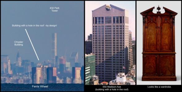
I did this two ways. First, quite similar to your approach with the Chrysler, I tried to estimate how much "wheel diameter" I would need to be aligned with the center of 432 Park. That's the skinny tower on the far right in the photo. I estimated about 60% of the wheel's diameter added to the right would align just right, and then I estimated a lat/lon from Google Maps.
Last night I spotted something even more useful: a building almost perfectly aligned with the very center of the wheel. It's an old building that was new when I first moved to NYC (I taught physics at Fieldston School from 1984-87). I always found it architecturally unappealing --gaudy even, but some people liked it, and it's instantly recognizable at a normal scale --I admit it's a bit amazing that I recognized it in this particular photo. The building used to be called the Sony Tower. Now it's just 550 Madison Ave. It's the building with the big circular hole in the pediment on the roof. To me it looks like furtniture, like an old wardrobe (see my attached image). But that hole is quite distinctive. It's not perfectly aligned with the center of the ferris wheel in our skyline photo, but we can easily estimate a little offset to get it right and then pull a latitude and longitude from Google Maps based on that.
So now we have two lines of position defined by two lat/lon pairs each:
LOP with Parachute Tower and E.S.B.: (40.57297°N, 73.9844°W), (40.74841°N, 73.98563°W),
LOP with Ferris Wheel and 550 Madison: (40.57403°N, 73.97914°W), (40.7615°N, 73.97308°W).
How do we determine where they cross?? That in itself is an interesting mathematical puzzle. What's the best way to proceed?
When I cross the two lines of position, either using the alignment with the skinny supertall, 432 Park, or with the "wardrobe" building, 550 Madison, I get a crossing point with the ESB/Parachute Tower LOP that lands about two-thirds of a nautical mile north of the spot you selected near that parking lot. My "solution" is 40°26.3' N 73° 59.005' W. As I noted previously, both points, and Bill Ritchie's, too, could easily fall inside a crazy-narrow error ellipse that would make those skinny towers in Manhattan look fat and bloated! Our lines of position are crossing with an angular separation of about 1°41' (roughly) which implies an error ellipse pointing nearly due north with a length in the north/south direction that is about 70 times greater than the east-west width. There's a much greater uncertainty in latitude than in longitude.
Frank Reed


