NavList:
A Community Devoted to the Preservation and Practice of Celestial Navigation and Other Methods of Traditional Wayfinding
From: Bill Ritchie
Date: 2022 Apr 25, 15:00 -0700
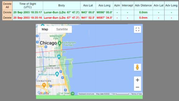
Starting with an very rough assumed position of N43 W090 and time of 18:30 UT and the given LDs and mean sextant altitudes, my cristal ball (less polished than Kermit’s and Frank’s) gives the time by lunar distance as 18:35:17 UT. ( IC -0.5 HoE 0, Sun LL Hs 47°16’, Moon UL Hs 24°46', LDs 67°47.3'.) The green arc on Image 1 shows the corresponding lunar line of position crossing the shoreline just South of the Adler planetarium. (See below for red arc.)
Making the (unjustifiable) assumption that the above given altitudes were correct, plotting the altitude position lines gave a 3 position line fix, making my first inspection answer N41° 52.4’ W087° 25.2 at 18:35:17 UT.
At that position, the Sun’s Meridian Passage was at 17:43:09. Adding the given 51m 30s gives a fix time of 18:34:39 UT. The time by lunar distance, 18:35:17, was 38 secs later so the longitude must have been 9.5’ West of W087° 25.2’. (Yes, West! I will never forget watching the ‘dawn’ rushing in from the West during the last few seconds of the total eclipse of Aug 11th, 1999 in my home port of Brixham.) So my second inspection answer, with latitude adjusted to stay on the lunar line of position, gives N41° 51.9’ W087° 34.4’ at 18:35:17. I found no need to adjust the lunar distance derived time as the Mer Passage time had changed an equal amount.
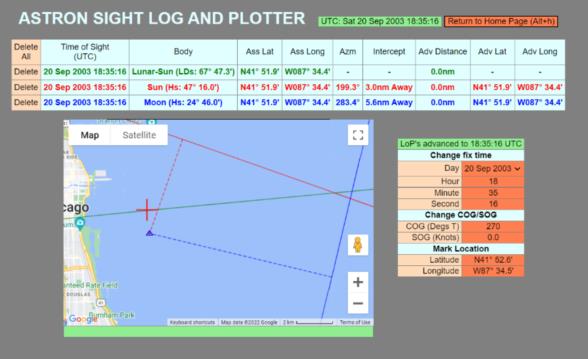
By refining the assumed position and time to the above values, my crystal ball advanced the lunar distance time by 1 second, moved the lunar line of position 0.6nm further North (red arc on Image 1) and the longitude by 0.1’ West. So my third inspection answer, based on the given lunar distance and mean altitude measurements, is N41° 52.6’ W087° 34.5’ at 18:35:16. Image 2 shows this position as a red cross, together with the three 18:35:16 position lines.
That is about 2 miles offshore! The NavList header photograph shows the waterline of the tall ship well short of the horizon, so it must have been taken from a significant height. Obviously not from the topgallant yard of an even taller ship, but perhaps from the roof walk of the planetarium?
In this body aspect, an error in LDs of +/- 0.1’ gives a time change of -/+ 9 seconds and a South/North displacement of 8.3nm in the lunar line of position (for the same body altitudes). Errors of 5’ in the Sun altitude values give around 7 secs time change or nearly 2’ of longitude. Similar changes to Moon altitude have less than half that effect on longitude.
Lunar derived UT with +/- 5’ variation in Sun and Moon altitudes. (Using first inspection results above) | ||||
Moon Alt | ||||
24° 51’ | 24° 46’ | 24° 41’ | ||
Sun Alt | 47° 21’ | 18:35:21 | 18:35:24 | 18:35:27 |
47° 16’ | 18:35:13 | 18:35:17 | 18:35:20 | |
47° 11’ | 18:35:06 | 18:35:09 | 18:35:12 | |
Bill Ritchie


