NavList:
A Community Devoted to the Preservation and Practice of Celestial Navigation and Other Methods of Traditional Wayfinding
From: Frank Reed
Date: 2019 Oct 2, 14:51 -0700
Yes, "grid navigation" is a standard coordinate trick near the poles. I'm sure someone else will give you a detailed account of that. I'll take a different tack...
Suppose your latitude is higher than 88°. Let's apply the intercept method, somewhat modified using the pole itself as an assumed position. There's no defined azimuth at the pole, so at first it seems as if we can't use the intercept method. But let's consider a specific set of observations.
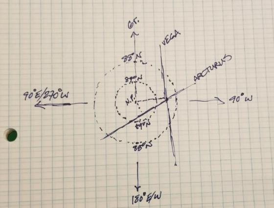
Suppose I visit the high Arctic tonight in the vicinity of 88° 30' N, 90° W. I measure the altitude of Vega tonight at 23:45:00 UT. I get 40° 21' after correcting for refraction and dip. Just a few seconds later, I grab a sight of Arcturus and get 19° 46' (again, after corrections, so both of these are Ho values). Now I open my almanac app, and I find that the GHA/Dec of Vega are 88° 15' / 38° 48' and for Arcturus 153° 31' / 19° 05'. Right about here, you notice that the Dec numbers are rather close to your observed altitudes.
Next you select the pole as an AP, and you realize why the Dec and Ho numbers are similar. At the pole, the true altitudes are exactly equal to the Declinations. So that means that the intercept distances are just Ho-Dec. That's the entire sight reduction calculation. For the Vega sight, the observed altitude is higher by 93' so the intercept distance is 93 n.m. towards Vega. For the Arcturus sight, the observed altitude is 41' higher so the intercept is 41 n.m. towards Arcturus. At the pole, there's no azimuth, but the longitude lines radiate out from an observer at the pole just as azimuth lines radiate outward from an observer's position anywhere else on the globe. And the GHA values are simply a type of longitude. The GHA of Vega is the longitude of Vega (the longitude of the sub-star point, or GP, where Vega is at the zenith). You use GHA for azimuth in this modification of the intercept method. Plot an intercept vector along longitude 88.2° with length 93 miles. Draw a line perpendicular. That's the Vega LOP. Plot an intercept vector along longitude 153.5° with length 41 miles. The line perpendicular to that is the Arcturus LOP. Where do they cross? That's your fix. I find a latitude of about 88° 27' and a longitude close to 90.2° (see the little sketch).
Frank Reed


