NavList:
A Community Devoted to the Preservation and Practice of Celestial Navigation and Other Methods of Traditional Wayfinding


From: Paul Dolkas
Date: 2017 Jul 22, 22:52 -0700
Frank-
As far as designing a sextant for future use on the moon or Mars, I kinda came to the same conclusion about halfway through my project. The more I thought about it, the less I felt that NASA or some other agency would ever spend the resources to design such a device. If I was designing a lunar or Martian rover, the on-board navigation system would consist of a gyrocompass and a odometer, and the computer would be constantly computing position using those two inputs for dead reckoning. (That’s basically how the Apollo lunar rover worked in the early 70’s.) In the future, for longer journeys, the gyrocompass would need to be periodically realigned, and the simplest way to do that would be using flight-proven star trackers, similar to the ones employed today on most satellites & spacecraft.
So with such a system, would you really need to include a sextant as an emergency backup? Especially considering the fact that a trip of any length away from base would always involve two rovers, so if one became disabled, the other would bring everybody home. Similarly, if the navigation system in one rover went on the fritz, they could reset it using the position coordinates from the other.
So my answer to my question was basically no. It would be difficult to justify the cost of developing a lunar or Martian sextant as a backup navigation device - UNLESS it could serve a dual purpose. So I switched the basic design from a hand-held sextant to a tripod mounted theodolite. It’s primary purpose would be to map and measure geological formations, just like it’s done on earth. However, it would also provide – free of charge – a means for determining position in an emergency. You would just have to provide the right software for a laptop or calculator to do the sight reduction.
The benefits of such a strategy are obvious. You really don’t need a hand-held device on land – there’s no boat rocking or airplane turbulence to worry about, so a tripod-mounted theodolite works just as well – better in fact. And they would already be quite practiced in its use, so additional training for navigation would be minimized. The design problem therefore became designing a digital theodolite PRIMARILY for geology & mapping purposes, while at the same time making sure it retained the ability take a star/sun sight, as well as triangulate a position from distant landmarks.
Paul Dolkas
From: NavList@navlist.net [mailto:NavList@navlist.net] On Behalf Of Frank Reed
Sent: Saturday, July 22, 2017 7:29 PM
To: paul@dolkas.net
Subject: [NavList] New false horizons? Just watch satellites...
If the goal is really navigation, then just use visual observation of low-altitude satellites, like the ISS (International Space Station). I have brought this up a number of times in the past ten years. By using nearby objects against the distant background of the celestial sphere we eliminate the need for the horizon or vertical and also we no longer need angle-measuring instruments like sextants. Isn't it time to stop fighting the last war? We don't need an enhanced sextant. Not on the oceans in the year 2017 nor ten years from now on the the surface of the Moon or Mars. A human-centered system and even more so an automated system can observe the positions of nearby satellites against the background stars and quickly, accurately determine a position fix. If you want to go beyond traditional celestial navigation, then go beyond it. There's a lot more to see in the sky now than there was sixty years ago!
So why don't people do this? First, it hasn't been converted into a complete system. There's no kit for it the way there is for traditional celestial navigation --not yet. Second, it's not always as easy as it with the ISS, so a purely visual system is helpful but not "always on". Third, somehow it seems almost too easy and seems to lack any "technique" to be learned, which I think many navigators find disappointing. Fourth, it requires recent access to a computing device as well as a few hundred bytes of Internet data (but unless you're preparing for a true apocalypse, this shouldn't be a problem). Fifth, on the Earth, in the troposphere, it's weather-limited like standard celestial navigation. Sixth, it demands a different level of familiarity with the constellations (at least in its non-automated form), but maybe that's a positive! And finally, for now, it's easy to see that it's more effective with the human out of the loop. This sort of navigation is ripe for full automation.
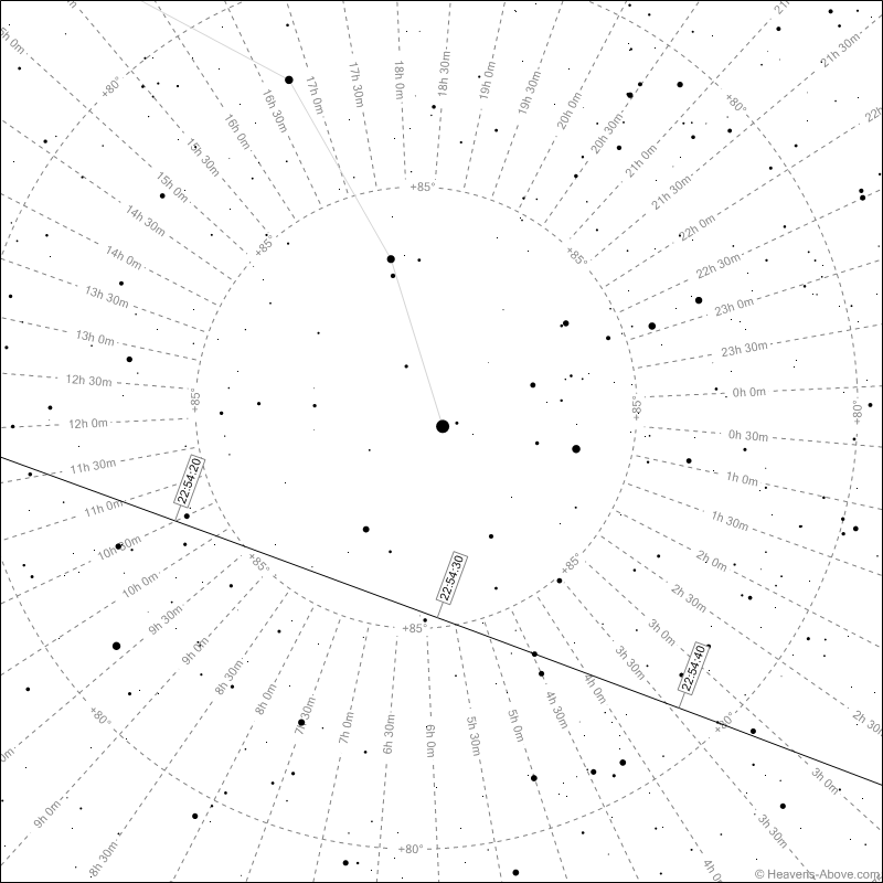
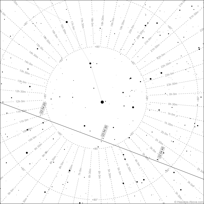
Below are charts for the ISS over southern New England tonight in about 45 minutes: one view for 41.5° N, the other for 41.6° N, with the longitude fixed at 71.3° W simply for this example. In case it's not immediately obvious from the coordinates, the bright star at the center is Polaris. The path among the background stars is shifted up by nearly a full degree from a tenth of a degree change in latitude. A casual observer with minimal training could readily determine latitude within a mile using only these charts and a pair of binoculars.
Frank Reed
Attached File:
Attached File: