NavList:
A Community Devoted to the Preservation and Practice of Celestial Navigation and Other Methods of Traditional Wayfinding
From: Michael Bradley
Date: 2018 Mar 14, 14:09 -0700
Hello again Jeremy
you wrote:
"My ship is finally getting an ECDIS and I am taking the CBT to learn how to use it. I have found that you can input range and bearings from visual and radar targets, but there is no capability to enter in Celestial LOP's."
My previous suggestion of using a single Longitude By Chronometer reduction needs only one sight, not two, to get an LOP on the screen.
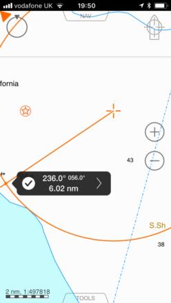
The attached screen shot from my iPhone using the unsophisticated app iSailor shows:
EP as the circular symbol enclosing a star - (not needed for plotting the LOP)
The LOP, drawn using the only free EBL available on the app, running from the position EPLat, LongByChron in the usual direction 90 degrees round from the Azimuth.
The example is from a sight with input data:
EP 54 02 N, 000 09E
Ho 39 47.6
gha 334 05.8
dec 08 14.1 N
and using an assumed Lat equal to the EP lat, 54 02 we get
LongByChron 000 16.6E, Zn 146, hence the LOP drawn at 146 + 90 = 236
The LongByChron and Azimuth method requires least computational effort those solutions offered so far, and least plotting effort to get the first LOP on the screen.
If you are seeking a professional mariner's description of examination type working a LongByChron, search for 'shipofficer Longitude By Chronometer'. It's relatively easy to automate using a programmable calculator, if required.
Good sailing
Michael Bradley


