NavList:
A Community Devoted to the Preservation and Practice of Celestial Navigation and Other Methods of Traditional Wayfinding
Re: Noon sun fix example
From: Peter Hakel
Date: 2009 Sep 17, 19:59 -0700
From: "Anabasis75@aol.com" <Anabasis75@aol.com>
To: NavList@fer3.com
Sent: Thursday, September 17, 2009 4:52:40 PM
Subject: [NavList 9784] Noon sun fix example
--~--~---------~--~----~------------~-------~--~----~
NavList message boards: www.fer3.com/arc
Or post by email to: NavList@fer3.com
To , email NavList-@fer3.com
-~----------~----~----~----~------~----~------~--~---
From: Peter Hakel
Date: 2009 Sep 17, 19:59 -0700
Jeremy,
From your data I obtain the following coordinates for your 1300 fix:
N 32 degrees 04.7'
W 75 degrees 33.0'
which agrees beautifully with your GPS fix.
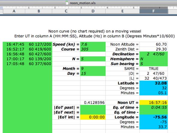
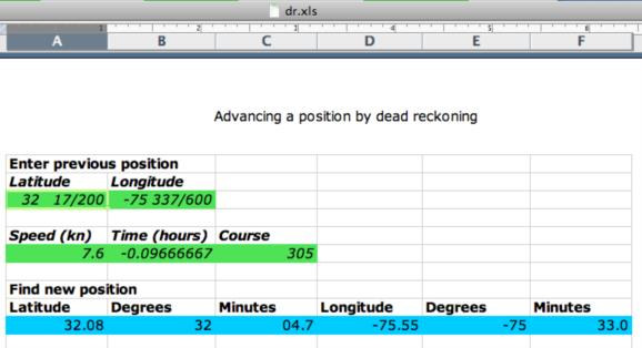
First, I converted all your LT's into UT's and Hs's into Ho's. These pairs of data I then entered into the "noon_motion" spreadsheet (see the first attached screenshot). From there I obtain your coordinates at the moment of your last observation. Using the "dr" spreadsheet (see the second attached screenshot) I retard this position by dead reckoning to 1300 LT.
Peter Hakel
From: "Anabasis75@aol.com" <Anabasis75@aol.com>
To: NavList@fer3.com
Sent: Thursday, September 17, 2009 4:52:40 PM
Subject: [NavList 9784] Noon sun fix example
I shot a "Wilson-esque" sun around noon with the worse possible combination
that I could get here on this voyage. Basically we were heading CRS 305 spd 7.6
knots (sailboat speed) in the middle latitudes (32 deg North) with the sun
descending towards the celestial equator at 1.1' per hour and a declination
around 3 degrees North.
Instead of a 30 line spread over 30 minutes as I have done in the past, I
tried a far more likely, and simple approach: 5 LOP's 2 before LAN, one "at"
LAN, and two after. They are shot as nearly equal intervals around LAN
(within a few seconds). They are nearly equal altitudes to boot, which was
unintentional as I was taking them by time not by arc.
I plotted the lines by standard trig reduction on the computer and gave a
very reasonable fix error at 1300 of 0.3 nm.
Here's the data.
Height of eye 103 feet
Index correction -1.2' (IE 1.2' on the arc)
Standard Temp & pressure
Sun, all lower limb observations.
Crs 305 deg True
Spd 7.6 knots
ZD +4
15 September 2009
GPS fix at 1300 Lat 32 deg 4.7' North; Long 075 deg 33.1' W
Data
Time (LT) Hs
12h 47m 45s 60 deg 33.8'
12h 52m 17s 60 deg 37.6'
12h 56m 48s 60 deg 38.4'
13h 00m 17s 60 deg 37.4'
13h 05m 48s 60 deg 33.4'
Find the 1300 fix by observation. (please attach any graphs if that
is the method of solving)
Jeremy
--~--~---------~--~----~------------~-------~--~----~
NavList message boards: www.fer3.com/arc
Or post by email to: NavList@fer3.com
To , email NavList-@fer3.com
-~----------~----~----~----~------~----~------~--~---


