NavList:
A Community Devoted to the Preservation and Practice of Celestial Navigation and Other Methods of Traditional Wayfinding
From: Frank Reed
Date: 2022 Nov 21, 12:24 -0800
In my most recent message on this one, I wrote:
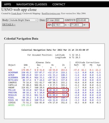
"Suppose your corrected altitude (Ho) for Regulus is exactly 26°00' and the corrected altitude for Pollux is exactly 28°30'. Determine your latitude. You should be able to do that! Pick a date in March of any recent year. Then find a combination of LHA Aries and Latitude that puts those stars at about the right altitudes. See it?? [UPDATE: The second attached image should give you some help picking an AP if you decide to do this with standard cel nav tools. Get a fix. Read off the latitude.]. Note that you can also do this by sky simulation in an app like Stellarium. What is your latitude?"
There's another way you can simulate this. Use the USNO web app (or my web app clone). Go here:
https://clockwk.com/apps/usnoclone/
And there you will see that we get exactly the altitudes for the stars required by the photo (or rather, required by my measurements of the photo): 26°00' for Regulus and 28°30' for Pollux. Problem solved! We're on the coast of Chile about 80 n.m. NNW of Santiago, capital of Chile. The latitude is thus 32°19.1' S. Hmm... it's a snowy day for the Chilean mid-coast. And impressive aurora for such a low latitude! But there's a problem with this solution, and it's instructive and useful for understanding two-body fixes generally. In the Chile solution (see attached), Regulus is about 40° to the right of Pollux in azimuth. In the photo Regulus is about 40° to the left of Pollux.
So play with latitudes and longitudes/times until the altitudes match and Regulus and Pollux are flipped left to right. What is the latitude?
Frank Reed
Clockwork Mapping / ReedNavigation.com
Conanicut Island USA


