NavList:
A Community Devoted to the Preservation and Practice of Celestial Navigation and Other Methods of Traditional Wayfinding
Re: (OFF-TOPIC) Flight 370
From: Gary LaPook
Date: 2014 Mar 26, 01:28 -0700
From: Gary LaPook
Date: 2014 Mar 26, 01:28 -0700
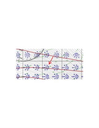
Looking at the navigation aspects of the the search vessels, the area is certainly a very difficult one as reference to the pilot chart reveals, I have attached an excerpt and indicated the wind rose just east of ninety degrees east longitude and just south of forty degrees south latitude. The entire pilot chart is available here:
First, as everybody has pointed out, the "roaring forties" is known for its strong westerlies. According to the chart, fully 78% of the time there is some westerly in the wind, 33% straight out of the west, 20% from the northwest and 15% from the southwest and those winds are force five. About 15% of the time the winds are force 4 from the north and northeast and 9% of the time the
wind is force eight, gale force.
Second, 30% of the time the wave height is twelve feet or greater!
Third, he magnetic variation changes by one degree about every three miles, ten degrees of change in five degrees of longitude! And the rates of variation change also differ significantly in a very short distance. I don't know how you keep a heading with a magnetic compass in an area like this.
Fourth, the plane was last reported at about 0011 Z on March 8th, eighteen days and eight hours ago. The pilot chart shows the current to be pretty consistent with the drift towards the east-northeast
at 0.6 knots. At that speed the wreckage should drift 14.4 NM per day and by now should have moved 264 NM from the point of impact.
As for any survivors, the water temperature is 12°C and the air temperature is only 14°C. According to the Air Force Survival Manual life expectancy in water that cold is less than six hours.
gl


