NavList:
A Community Devoted to the Preservation and Practice of Celestial Navigation and Other Methods of Traditional Wayfinding
From: Frank Reed
Date: 2015 Jan 9, 11:17 -0800
Sam L., you wrote:
"What I'm trying to figure out is how you get a position fix when you don't have an obvious AP Latitude or AP Longitude?"
An AP is literally arbitrary, so it's not quite the right word and concept here. I think what you're really asking is what do we do when we don't have any estimate of our position (some people who like acronyms call that an "EP"), or when the DR position is radically incorrect. The short answer is that this never happens in the real world. Sure, if you're trying to figure out observations that have been handed to you with no context, like that video you watched, then you face this problem, but that's a case of celestial detective work rather than navigation. In real navigation, you're never lost. You always have a reasonable estimate of your actual position, especially in the modern world. Remember that: you're never lost. Navigation is always a process of refinement of position using all available data.
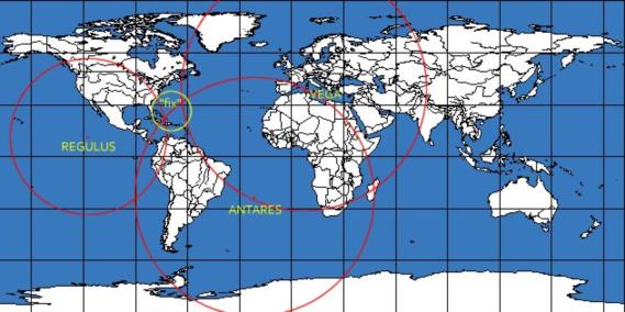
But suppose you're playing "celestial detective". You've "found" some observations in some documents, and you want work out a fix without any starting point --no estimate of your position. How do you proceed? First, you make a guess. This is especially useful when you have a set of nearly simultaneous star sights. Your first goal should be to estimate the declination of a star at the zenith since this is identical to your latitude (it's a rule: "the declination of the observer's zenith is the observer's latitude", by definition). You can do this with little more than a star chart. For example, suppose you made observations today (Jan. 9, 2015) within a couple of minutes of 10:49 UT/GMT. You observed Vega 21° high in the northeast, Antares (also) 21° high in the southeast, and Regulus 44° high in the west. Grab a star chart and you can make a good rough estimate of the latitude by drawing circles around those stars with radii equal to observed zenith distance. Try it, and tell us what you get. Longitude requires a small calculation, but nothing too complicated. You can also proceed using a globe instead of a star chart: plot the Dec and GHA of each star as latitude and longitude on a globe (Dec=Lat, GHA=Lon measured west). Draw a circle around each star's lat/lon with radius equal to the star's observed zenith distance. Your position is near the spot where the circles cross (note: this really requires an actual globe, but in latitudes not too near the poles and for zenith distances that aren't too large, you can get some success with an ordinary flat map of the Earth in common projections). Then it's just a matter of trial and error. Try an assumed position based on your estimated latitude and longitude. Then see where the LOPs cross. If it's hundreds of miles away, try again with another assumed position close to the position derived from the first one. Usually you'll find yourself within "normal" plotting range after just three trials.
By the way, have you installed Stellarium on your computer yet? You can easily create your own sample cases rather than seeking out random youtube videos. For example, here's the details for the data above:
January 9, 2015, UT=10:43:20:
Vega 21° 07',
Antares 21° 14',
Regulus 44° 49'.
Stellarium has no adjustment for height of eye, so assume your eyes are right at sea level. For GHA and Dec data, you can use the standard USNO online data here (in fact you can do trial and error on the position there, too, and looking at the altitudes, find your position quickly, if you're so inclined). Then plot the GHA and Dec on a map and draw circles. I've attached an example of this for the data above. Since it's a flat map rather than a globe, the result is only a crude approximation, but that's your first estimate. From there you can narrow down easily.
Frank Reed
ReedNavigation.com
Conanicut Island USA


