NavList:
A Community Devoted to the Preservation and Practice of Celestial Navigation and Other Methods of Traditional Wayfinding
From: Frank Reed
Date: 2017 Feb 11, 09:32 -0800
Hi David.
You're doing it wrong. :) It most certainly works, exactly as advertised, and anywhere on the globe.
Part of the problem is that we are accustomed to "sky pointers" that work on flat projections. For example, I can draw the stars in the northern sky on a flat piece of paper and sketch in a line running down from the north star to the horizon. That diagram is quite effective for middle latitudes in the northern hemisphere. This Orion trick is different. It's three-dimensional. I tried to explain this carefully in my original message, but I will add more to it here.
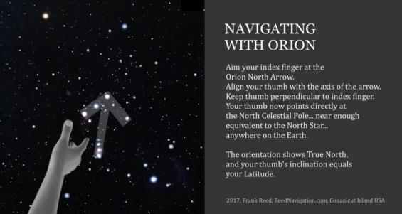
Step one: make a gun with your hand. You remember this... like we did when we were kids, you point your index finger and hold up your thumb like the cocked hammer of the gun (your other fingers are curled under as if gripping the handle of the gun). There is one additional refinement that we need for this procedure. You need to hold your thumb up so that it is perpendicular to your index finger. Some people find this difficult, and if you do you will have to imagine your thumb in that extended position, pointing ninety degrees from your index finger.
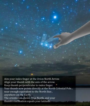
Step two: go outside and point your index finger at the point of the Orion North Arrow (again, the point is the star Mintaka). Then rotate your hand until your thumb is aligned with the axis or shaft of the arrow, as in this image:

Step two-a: If you want to be more careful and get the orientation within a degree or two, then you should rotate your hand 8° counter-clockwise. This aligns your thumb with an axis more nearly along the line from the end of the sword to the star at the center of Orion's belt. Right about here, someone will say, "well, if I have to change my orientation, then why should I bother with this? Why not just use a pair of stars aligned perfectly with the north star? This ain't no good... I'm gonna use something else." The big advantage of the Orion North Arrow is that it's bright, and it really jumps out at you once you recognize it. You'll see it pointing north regularly and without fail once you've seen it properly a few times. Even if you do not rotate your pointer by those eight degrees, the direction that you estimate this way is excellent for a quick check.
Step three: look at your thumb as a three-dimensional pointer. When you have your hand aligned like this, your thumb is pointing right at the north celestial pole. It is, in fact, completely analogous to the gnomon of a sundial or the polar axis of an equatorial mount for a telescope at this point. It defines an axis parallel to the Earth's axis. Your thumb is pointing north in true compass direction, and it is inclined up from the horizon at an angle equal to your latitude. In the southern hemisphere, since your thumb is pointing below the horizon, the inclination angle is negative and that corresponds to a negative latitude (negative latitudes are southern latitudes). It's easiest to see the latitude from inclination relationship when Orion is rising or setting. At that time your arm is pointed nearly horizontal, and you can more clearly see the angle between your thumb and the horizon. It equals your latitude. But make no mistake, this is true at any time of night, you simply have to picture the inclination of your thumb relative to the horizontal plane.
Suppose you look at this and say to yourself that this is not accurate enough to be useful. Of course you're not going to get your latitude from this in the same way that you would by measuring a meridian altitude of a star -- not even close. But it's excellent for a rough estimate of latitude, and it's great for compass direction. Nonetheless, if you want more, there are ways to get more. For example, find a piece of cardstock, even an index card. Point the long edge of the card at Mintaka. Then rotate it to align with the axis of the arrow, either the visual axis or the slightly rotated "better" arrow. Now the short edge of the card is quite accurately aligned with the axis of the Earth, pointing north-south and inclined at the observer's latitude. You could even mount a small rectangular board on a tripod and measure angles. The results will be as accurate as your apparatus. This is not something that I recommend. Shoot it with your hand and call it a day. But if you need accuracy, you can get it.
Frank Reed
ReedNavigation.com
Conanicut Island, New England


