NavList:
A Community Devoted to the Preservation and Practice of Celestial Navigation and Other Methods of Traditional Wayfinding
From: Antoine Couëtte
Date: 2024 Jan 11, 20:20 -0800
Lighthouse : N52°49.2' / E001°32.2' Height above ground 26 m / 85'
Approximate distance :
Rigel - Betelgeuse angular separation : 18.6° (119 mm on my enlarged printed copy)
Lighthouse : 39 mm Hence angular size 18.6 * (39/119) = 6.1°
Distance from lighthouse : 26 m / tan 6.1° = approximately 243 m . Probably the biggest uncertainty here : hence the error ellipse great axis goes in the same azimuth as the lighthouse.
Approximate Azimuth :
The only "reliable" data is the vertical line given by the lighthouse elevation. The Rigel / Betelgeuse intersects it with departure angle from Rigel = 63° . From previous recent experience somewhere in the Pacific Ocean, we will use the departure angle as our "best" time indicator.
"rough altitudes" : Rigel : 18° / Betelgeuse 26.5°
Choose any date which floats your boat. Same end-result anyway. Picture assumed here to be taken on Jan 11th, 2024.
From rough altitudes and Lighthouse position, get Approximate UT = 18h46m (yielding Rigel 18° / Betelgeuse 26.4°) with departure Angle at 60.2° (vs. 63°)
Departure angle at 63° is obtained at 18h18m for which : Rigel 16°12.3' / 126°06.7' and Betelgeuse 22°26.9' / 108°12.9'
Such altitudes still compatible with overall picture (picture horizon being quite unreliable, that's good on us).
Light house Azimuth very close then from 123° .
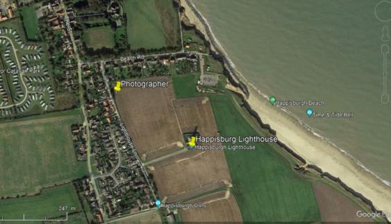
Working backwards from Lighthouse, get Photographer's position as per attachment.
Biggest error on distance, Azimuth should be more reliable.
Wet finger accuracy guess:
Error ellipse centered on observer's position.
From uncertainty on both vertical angular elevation (6.1°) and actual masonry height above ground (26m) : ellipse total length (1 sigma) 70 m oriented from Observer towards lighthouse.
Ellipse width (1 sigma), assuming Azimuth error inferior to 2° : 243 m * sin 2° = about 10 meters.
My best guess.
From position and picture time here-above, easy to get the extra requested data (GHA Aries und so weiter).
Thanks one again for the drill,
Kermit


