Welcome to the NavList Message Boards.

NavList:

A Community Devoted to the Preservation and Practice of Celestial Navigation and Other Methods of Traditional Wayfinding

Compose Your Message

Message:αβγ
Add Images & Files
    Name or NavList Code:
    Email:
       
    Reply
    Re: Orion and a lighthouse... where are you?
    From: Antoine Couëtte
    Date: 2024 Jan 11, 20:20 -0800

    Lighthouse : N52°49.2' / E001°32.2' Height above ground 26 m / 85'

    Approximate distance :

    Rigel - Betelgeuse angular separation : 18.6° (119 mm on my enlarged printed copy)

    Lighthouse : 39 mm Hence angular size 18.6 * (39/119) = 6.1° 

    Distance from lighthouse : 26 m / tan 6.1° = approximately 243 m . Probably the biggest uncertainty here : hence the error ellipse great axis goes in the same azimuth as the lighthouse.

    Approximate Azimuth :

    The only "reliable" data is the vertical line given by the lighthouse elevation. The Rigel / Betelgeuse intersects it with departure angle from Rigel = 63° . From previous recent experience somewhere in the Pacific Ocean, we will use the departure angle as our "best" time indicator.

    "rough altitudes" : Rigel : 18° / Betelgeuse 26.5°

    Choose any date which floats your boat. Same end-result anyway. Picture assumed here to be taken on Jan 11th, 2024. 

    From rough altitudes and Lighthouse position, get Approximate UT = 18h46m (yielding Rigel 18° / Betelgeuse 26.4°) with departure Angle at 60.2° (vs. 63°)

    Departure angle at 63° is obtained at 18h18m for which : Rigel 16°12.3' / 126°06.7' and Betelgeuse 22°26.9' / 108°12.9'

    Such altitudes still compatible with overall picture (picture horizon being quite unreliable, that's good on us).

    Light house Azimuth very close then from 123° .

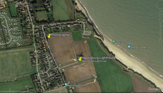
    Working backwards from Lighthouse, get Photographer's position as per attachment.

    Biggest error on distance, Azimuth should be more reliable.

    Wet finger accuracy guess:

    Error ellipse centered on observer's position.

    From uncertainty on both vertical angular elevation (6.1°) and actual masonry height above ground (26m) : ellipse total length (1 sigma) 70 m oriented from Observer towards lighthouse.

    Ellipse width (1 sigma), assuming Azimuth error inferior to 2° : 243 m * sin 2° = about 10 meters.

    My best guess.

    From position and picture time here-above, easy to get the extra requested data (GHA Aries und so weiter).

    Thanks one again for the drill,

    Kermit
    File:


    Reply
    Browse Files

    Drop Files

    NavList

    What is NavList?

    NavList is a community devoted to the preservation and practice of celestial navigation and other methods of traditional position-finding. We're a group of navigators, navigation enthusiasts and hobbyists, mathematicians and physicists, and historians interested in all aspects of navigation but primarily those techniques which are non-electronic.

    To post a message, if you are already signed up as a NavList member, start a new discussion or reply to any posted message and use your posting code (this is a simple low-security password assigned when you join). You may also join by posting. Your first on-topic messsage automatically makes you a member, and a posting code will be assigned and emailed to you for future posts.

    Uniquely, the NavList message boards also permit full interaction entirely by email. You can optionally receive individual posts or daily digests by email, and any member can post messages by email (bypassing the web site) by sending to our posting address which is "NavList@NavList.net". This functionality is similar to a traditional Internet mailing list: post by email, read by email, reply by email. Most members will prefer the web interface here for posting and replying to messages.

    NavList is more than an online community... more about that another day.

    © Copyright notice: please note that the rights to all messages and posts in this discussion group are held by their respective authors. No messages or text or images extracted from messages may be reproduced without the explicit consent of the message author. Email me, Frank Reed, if you have any questions.

    Join / Get NavList ID Code

    Name:
    (please, no nicknames or handles)
    Email:
    Do you want to receive all group messages by email?
    Yes No

    A NavList ID Code guarantees your identity in NavList posts and allows faster posting of messages.

    Retrieve a NavList ID Code

    Enter the email address associated with your NavList messages. Your NavList code will be emailed to you immediately.
    Email:

    Email Settings

    NavList ID Code:

    Custom Index

    Subject:
    Author:
    Start date: (yyyymm dd)
    End date: (yyyymm dd)

    Visit this site
    Visit this site
    Visit this site
    Visit this site
    Visit this site
    Visit this site