NavList:
A Community Devoted to the Preservation and Practice of Celestial Navigation and Other Methods of Traditional Wayfinding
From: Frank Reed
Date: 2024 Jan 11, 10:36 -0800
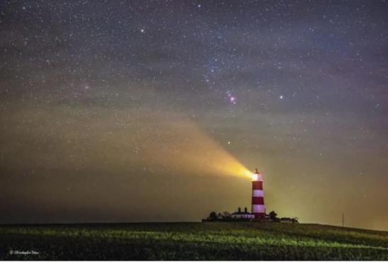
Here's a pretty picture. Let's geek it up with math! :)
This is Happisburgh Lighthouse with Orion looming behind it in a photo by Christopher Dean. You can look it up on Wikipedia to get details on it. Then from the appearance of the stars, you should be able to lock down the photographer's location at the time the image was captured with some accuracy. It's a fun and fairly straight-forward navigation puzzle: where are you? (assuming you're imagining yourself in the photographer's shoes). Details of the lighthouse provide an angular scale. Comparison with Orion provides an angular scale. You do not need trigonometry for angles as small as these! You'll also want some astronomical simulation software. A visual simulation like Stellarium could be highly useful. You could also do it "by the numbers" with something like my USNO Clone web app (I preset the lat/lon more or less, but you'll have to adjust the time and perhaps other parameters).
How accurate is this? Nearest ten feet? Better? Worse...? To make things a little more interesting, can you draw a reasonable error ellipse around the position that you're able to determine from the photo? How do you think the ellipse would be oriented? In what direction would its long axis point? What would you estimate for the lengths of the axes of the ellipse? Let's go with a 1 s.d. error ellipse as a specific choice, but don't worry about that too much ...likelier than not, where are you?
And for extra credit, what would you estimate is the LHA of Aries (equivalent to Local Sidereal Time) at the time of the photo? You could also specify the SHA of the meridian at the time of the sight.
Frank Reed


