NavList:
A Community Devoted to the Preservation and Practice of Celestial Navigation and Other Methods of Traditional Wayfinding
From: Frank Reed
Date: 2023 Jul 30, 14:09 -0700
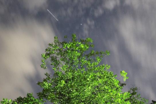
Here's a nice photo taken last night by Reggie D. in North Carolina and posted on Facebook. The time of the photo is 9:54pm Eastern US time on 29 July, equivalent to 01:54 UT on Greenwich date 30 July 2023. The exact time is not known better than that.The photo shows a short trail of the International Space Station. The trail begins or ends at some time starting at 54 minutes after the hour. As bright as it is, we have the advantage here of a near certain identification: it's the ISS.
There's a very bright star above the treetop, too. We're facing a bit north of east. Can you identify it? The bright star is on the corner of a small triangle of stars, and that triangle is attached to a parallogram of four stars. Easy, right? To make this into a more interesting navigation problem, I'm going to add in an observation that was not actually made. Let's suppose that the altitude of that bright star, seen high in the east, was measured "by some means" and found to be 73°30.3' +/-0.5', after the usual correction for refraction, at 01:55:30 UT.
This is a hybrid "celestial" navigation problem. The star altitude places us on an ordinary celestial line of position. That LOP runs close to north-south since the star's azimuth is close to east.
The satellite (ISS) trail in the photo places us on a different kind of line of position. We can determine the satellite's position among the background stars. Since the time is not exactly known, and since the image is trailed, our observer could be anywhere along a trackline on the Earth's surface. We can determine points on this satellite LOP by pure simulation. Use heavens-above.com, for example, and find points where the satellite would appear at just the right spot near that bright star for a time of 01:54 UT. The two lines of position intersect, and that gives us a fix. Note that the satellite LOP is roughly parallel to, but not the same as, the satellite ground track (the set of points directly below the satellite, as it orbits, on the Earth's surface). That ground track runs northwest to southeast over Tidewater Virginia.
So where are we? Where was the observer when this photo was taken the additional altitude for the bright star? Simulate the satellite pass, match it to the appearance of the photo. Work the star sight as usual. Find a fix. And if you ignore that hypothetical altitude info, where else could we be??
Frank Reed
Clockwork Mapping / ReedNavigation.com
Conanicut Island USA


