Welcome to the NavList Message Boards.

NavList:

A Community Devoted to the Preservation and Practice of Celestial Navigation and Other Methods of Traditional Wayfinding

Compose Your Message

Message:αβγ
Message:abc
Add Images & Files
    Name or NavList Code:
    Email:
       
    Reply
    Re: Position from altitude and azimuth.
    From: Frank Reed
    Date: 2020 May 19, 08:04 -0700

    Bill,

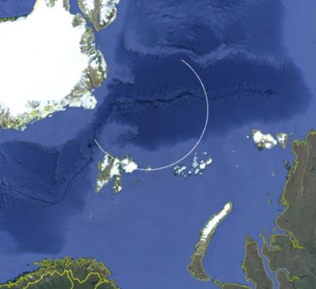
    After I said on Facebook this a.m. that I was done for the night, just as you were waking up in your longitude, I stayed up another hour having a nightcap and wrote a little bit of code to generate KML (Google Earth viewable) files of the "isoazimuth curves." And yes, I'm convinced now. They are only approximated by small circles in the case of high Dec (Polaris, e.g.). Sample below for Dec=80°. In other cases, the curves are sometimes roughly small circles for certain azimuth ranges, but they quickly become radically different curves. 

    Frank Reed
    File:


    Reply
    Browse Files

    Drop Files

    NavList

    What is NavList?

    Get a NavList ID Code

    Name:
    (please, no nicknames or handles)
    Email:
    Do you want to receive all group messages by email?
    Yes No

    A NavList ID Code guarantees your identity in NavList posts and allows faster posting of messages.

    Retrieve a NavList ID Code

    Enter the email address associated with your NavList messages. Your NavList code will be emailed to you immediately.
    Email:

    Email Settings

    NavList ID Code:

    Custom Index

    Subject:
    Author:
    Start date: (yyyymm dd)
    End date: (yyyymm dd)

    Visit this site
    Visit this site
    Visit this site
    Visit this site
    Visit this site
    Visit this site