NavList:
A Community Devoted to the Preservation and Practice of Celestial Navigation and Other Methods of Traditional Wayfinding
From: Andrés Ruiz
Date: 2018 Mar 12, 10:04 +0100
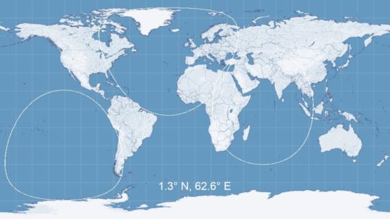
Sometimes it's nice to get a complete circle of position with points evenly-spaced all the way around the circle, for plotting or for visualization, or maybe even for drawing in the ECDIS option that's currently being discussed. There are a couple of ways to do this, but I think the simplest is to start with the star directly above the north pole and then rotate down to the correct declination. You set up an array of points at a fixed latitude which is equal to the zenith distance (90°-alt). These should be spaced at uniform intervals of longitude, for example every half a degree. So for example, if the body is exactly 60.50° high, then your array would have points (29.5, 0), (29.5,0.5),(29.5, 1.0)... up to (29.5, 359.5). Then you take those points and rotate each of theem down to the actual declination of the body in question. That's a rotation from an initial dec of 90° down to whatever the body dec is, so the rotation angle is 90°-dec. There are standard formulae for a coordinate rotation which I won't bother posting right now. If you want to look this up, it's identical to a rotation from e.g. ecliptic to equatorial coordinates with the obliquity (23.4°) replaced by 90°-dec. Then the transformation by longitude is easy. You just add the body GHA onto each of the longitudes in the rotated array. In the map attached below, I've used this algorithm to draw three random circles of position on an equirectangular projection (that's a simple x-y plot of latitude and longitude).
Frank Reed
Clockwork Mapping / ReedNavigation.com
Conanicut Island USA


