NavList:
A Community Devoted to the Preservation and Practice of Celestial Navigation and Other Methods of Traditional Wayfinding
From: Robert Bernecky
Date: 2017 Dec 10, 07:07 -0800
As a follow-up to all the helpful messages you have received: Your numbers from Pub 229 look good.
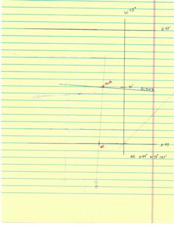
Using Lat 44, Lon W 73º 18.7' (i.e. LHA 2), Dec N12º, (Same Name as Lat) we extract Hc 57º 57.2' d +60.0' Z 176.3º
The actual declination for the sun is N 12º 12.7' and we either use the interpolation tables (those can be confusing!), a calulator e.g. dec_inc/60 * d, or in this case, by eyeball (d= +60 means a dec_inc of 12.7 results in exactly 12.7 as the correction). In any case, we get
Hc 57º 57.2' + 12.7' = 58 09.9'. Zn = 360 - Z (when LHA < 180, as the case here) = 183.7º
Pub 229 relies on a graphical solution -- once we get these numbers we are only half done.
We find the intercept: Ho - Hc to get 57º 40.0' - 58º 09.9' = 57 40 - 47 69.9 = -29.9 i.e. 30 nm Away. (or remember HoMoTo, Ho Mo(re than Hc), To(ward). We plot the AP point, draw a line pointing in the direction of the body, mark off 30 nm away from the body, and finally, draw in a Line of Position (LOP), perpendicular. See the attached.
In theory, we are near or on the LOP, but to get a fix, we need at least one more LOP that intersects with this one.
At least for me, plotting can take quite a bit of time.... but if you did this for a living I imagine you learn how to do this accurately and efficiently, all the while bouncing around in an airplane.


