NavList:
A Community Devoted to the Preservation and Practice of Celestial Navigation and Other Methods of Traditional Wayfinding
From: Frank Reed
Date: 2018 Oct 31, 16:14 -0700
Rafal, you wrote:
"And eventually I want to compile something that will last more then just 5 years. And will give the best accuracy possible. Hence 0.1' numbers for Hc and 0.1° for Zn."
There's no harm in the increased precision in azimuth since a tenth of a degree is still a fairly big angle, though arguably there isn't much value either. But the tenth of a minute precision in the altitudes is just garbage data (unless you create monthly or even daily tables).
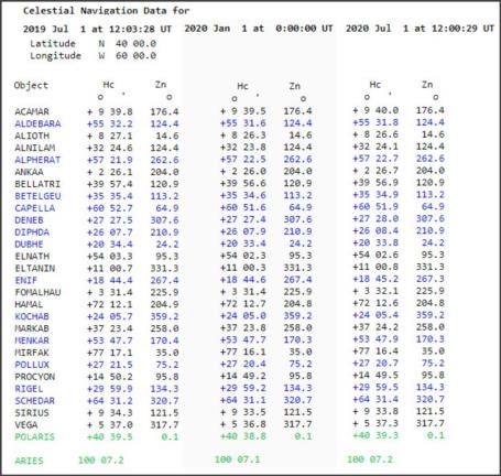
May I suggest an experiment for you. Select a random Lat, LHA Aries pair. Now prepare your 249-like tables for three epochs: 2019.5, 2020.0, and 2020.5. I'm attaching an example of this culled from the USNO web data page in which I'm setting the UT to 00:00:00 on Jan.1, 2020 and then adjusting the UT on the other dates to yield, as nearly as possible, the same LHA Aries. Notice the differences in six months on either side of January 1, 2020.
Now you might think to yourself that you can manage these inter-year changes simply by including a more detailed P&N (precession and nutation) table, but it won't work. A large fraction of the variation you see in the sample data here is due to stellar aberration which is cyclic over a year and cannot be corrected for using a simple lookup like the P&N table. Your choices are fairly straight-forward: round to the nearest minute of arc, like the traditional versions of Pub.249, or prepare tables for every month.
Formerly, the monthy table option was a non-starter except in some specialty cases because it wasted paper. But you're not creating tables that will be printed for every case. Your prospective market consists of navigators who might need the tables for two or three weeks out of the year. So why not create data files for each and every month (or week, or even day) from November 2018 and on out into the future as far as you like? Then you can justify the increased precision that so far cannot be justified, and you can also entirely bypass the issue of P&N tables.
Any navigator (or navigation enthusiast) who wants them can print out tables for a given range of latitudes for the specific month or two as required. If you go for daily tables, then another nice option arises. Since the stars are only visible in twilight, if they are published daily, you only need two rather narrow bands of LHA Aries to cover evening and morning twilight for the latitude in question. Twenty minutes in each twilight is a five degree range in LHA Aries, so ten degrees total for the day. Suddenly what had seemed like a great increase in the published data collapses down to a manageable size again. Nice, right?
Frank Reed


