NavList:
A Community Devoted to the Preservation and Practice of Celestial Navigation and Other Methods of Traditional Wayfinding
Re: Read the vernier, get the noon latitude
From: Gary LaPook
Date: 2018 Feb 6, 20:16 +0000
From: Frank Reed <NoReply_FrankReed@navlist.net>
To: garylapook@pacbell.net
Sent: Tuesday, February 6, 2018 11:50 AM
Subject: [NavList] Read the vernier, get the noon latitude
Attached File:


From: Gary LaPook
Date: 2018 Feb 6, 20:16 +0000
Hs 73° 54'
IE 0
Dip - 3.4'
Ha 73° 50.6'
Ref/Sd + 15.7'
Ho 74° 06.3'
89° 60.0'
- 74° 06.3'
ZD 15° 53.7'
Decl 23° 24.2' North
Lat 39° 17.9' North
But since you started off with a sextant altitude only given to 1 minute precision then it is only valid to give the latitude to that same level of precision so the the correct answer is 39° 18' North.
gl
From: Frank Reed <NoReply_FrankReed@navlist.net>
To: garylapook@pacbell.net
Sent: Tuesday, February 6, 2018 11:50 AM
Subject: [NavList] Read the vernier, get the noon latitude
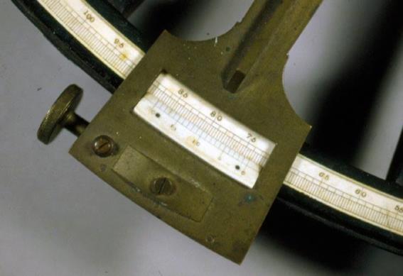
Not the best photo but readable. What do you get for the altitude on this octant? 73° and...
Assuming that it's the Sun's Noon altitude (almost certainly "LL"), and the GMT is about 17:00 (within an hour) and the date is June 18 (year indeterminate but after the invention of the digital camera), and height of eye is average for a medium-sized vessel, let's say 12 feet, and assuming that the observer's shadow was pointing north at noon, what is the latitude?
Frank Reed
Attached File:


