NavList:
A Community Devoted to the Preservation and Practice of Celestial Navigation and Other Methods of Traditional Wayfinding
Re: Santa Barbara 2016: Venus sight
From: Stan K
Date: 2016 Dec 13, 17:08 -0500
From: Stan K
Date: 2016 Dec 13, 17:08 -0500
Peter,
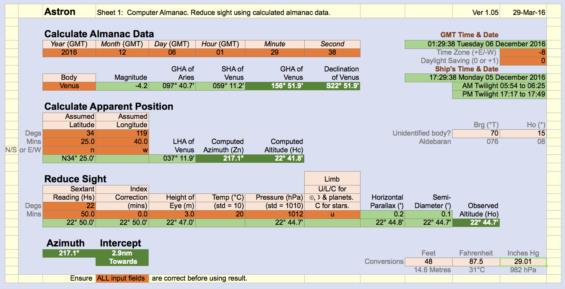
Looking at your spreadsheet, I see that you apply altitude corrections sequentially, showing the result at each step. When you reach semi-diameter, you subtract it from the previous value. In a sextant telescope, we essentially treat all planets as point sources, with semi-diameters of zero, by "splitting" the planet with the horizon. But to allow semi-diameter to be considered in an observed altitude calculation, as if we had a much more powerful telescope, we would have to consider whether we are observing the upper of lower limb. You subtract, implying the upper limb. Why do you do that? I note that the USNO Celestial Navigation Data site adds semi-diameter (to refraction and parallax) to get the sum, implying the lower limb, with no further explanation. That is also a source of confusion for me.
Stan
-----Original Message-----
From: Peter Hakel <NoReply_PeterHakel@navlist.net>
To: slk1000 <slk1000@aol.com>
Sent: Mon, Dec 12, 2016 8:20 pm
Subject: [NavList] Santa Barbara 2016: Venus sight
From Excel:
Venus on 2016 December 6, at 01:29:38 UT
GHA: 156° 51.9’
Dec: S 22° 51.9’
Ho: 22° 45’
Hc: 22° 42’
Intercept: 3’ Toward
Azimuth: 217°
Attached File:


Attached File:


Attached File:


Attached File:


From: Peter Hakel <NoReply_PeterHakel@navlist.net>
To: slk1000 <slk1000@aol.com>
Sent: Mon, Dec 12, 2016 8:20 pm
Subject: [NavList] Santa Barbara 2016: Venus sight
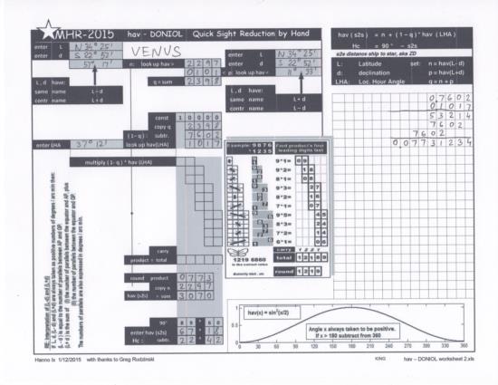
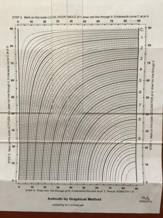
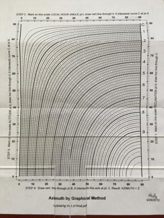
Last Tuesday evening in Santa Barbara I had the pleasure of a face-to-face meeting with a NavList member - Greg Rudzinski. He generously gave me a few goodies - including a printout of Hanno Ix’s azimuth diagram and a haversine table. I decided to reduce my Venus sight from the day before with the non-electronic hav-Doniol method.
AP: Latitude = N 34° 25', Longitude = W 119° 40'
From Excel:
Venus on 2016 December 6, at 01:29:38 UT
GHA: 156° 51.9’
Dec: S 22° 51.9’
Ho: 22° 45’
Hc: 22° 42’
Intercept: 3’ Toward
Azimuth: 217°
For the Hc I used the haversine tables posted some time ago on Navlist, which are in increments of 2’; I obtained Hc = 22° 42’, so that agrees.
The azimuth diagram gave me 37, which I added to 180 to obtain 217. Using a T-Plotter helps avoid making marks on the diagram, thus preserving it for future repeated use (see attached jpg's). Coincidentally, in this case the diagram wasn’t really needed; since the declination (step 1) and Hc (step 3) round to the same whole-degree value of 23, therefore the azimuth angle (step 4) comes out equal to LHA (step 2), which is 37.
Peter Hakel
Peter Hakel
Attached File:

Attached File:

Attached File:

Attached File:


