Welcome to the NavList Message Boards.

NavList:

A Community Devoted to the Preservation and Practice of Celestial Navigation and Other Methods of Traditional Wayfinding

Compose Your Message

Message:αβγ
Message:abc
Add Images & Files
    Name or NavList Code:
    Email:
       
    Reply
    Re: Shadow sights for longitude
    From: David Fleming
    Date: 2018 Jan 12, 19:40 -0800
    Mark, I meant to present an idea that would open a shadow instrument up to in principle sextant level accuracy.  

    A backstaff or an astrolabe had edges which produce shadows as John Brown is doing and suffers from umbra/penumbra uncertainty ie. light from all points of the sun showing at the same points in the measurement plane.  

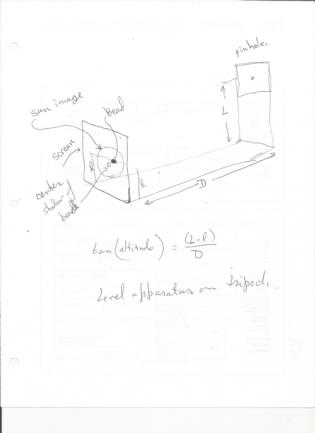
    If instead of an edge we use a pinhole, then we will get an image of the sun which gets bigger the further we get from the pin hole.  I then meant to suggest we could use say a hat pin or a small bead on a thin rod as an inicator to mark the center of the image.

    I've attached a sketch of what this might look like.  You would level the device on a tripod and change position (L) of pinhole to produce an image of the sun on the paper with the bead centered.

    Cheers,
    Dave

    On Fri, Jan 12, 2018 at 5:33 PM, Mark Knudsen <NoReply_Knudsen@fer3.com> wrote:
    I am familiar with pin holed cameras have taken  many photos with them. I could use a little more detail for the use of a ball  .it sounds  interesting  I am very interested in simplified practical navagation methods on land  thanks  mark

    On Jan 12, 2018 4:31 PM, "David Fleming" <NoReply_Fleming@fer3.com> wrote:

    Increaseing shadow length will not improve the accuracy.  As has been noted the accuracy is limited by the sun not being a point source of light.  A sextant  or the observers eye in the case of a sextan sight taken without a telescope produces an image of the sun atop the horizon, so that the angle to a specific point on the sun is measured.

    If you wish to achieve such accuracy using shadows, then build a pin hole camera. And position a small ball in the center of the image.  Then the angle of the ray from the pinhole to the ball relative to the horzontal will more accurately duplicate a sextant height measurement.

    The reference to longitude is only due to John's taking prime vertical sights.  Apply to meridian transit sights and you have latitude.

    DaveF


    File:


    Reply
    Browse Files

    Drop Files

    NavList

    What is NavList?

    Get a NavList ID Code

    Name:
    (please, no nicknames or handles)
    Email:
    Do you want to receive all group messages by email?
    Yes No

    A NavList ID Code guarantees your identity in NavList posts and allows faster posting of messages.

    Retrieve a NavList ID Code

    Enter the email address associated with your NavList messages. Your NavList code will be emailed to you immediately.
    Email:

    Email Settings

    NavList ID Code:

    Custom Index

    Subject:
    Author:
    Start date: (yyyymm dd)
    End date: (yyyymm dd)

    Visit this site
    Visit this site
    Visit this site
    Visit this site
    Visit this site
    Visit this site