NavList:
A Community Devoted to the Preservation and Practice of Celestial Navigation and Other Methods of Traditional Wayfinding
From: Frank Reed
Date: 2022 Feb 3, 09:15 -0800
Yeah, the article you linked covers it fairly well. Not much has changed in the past decade except one individual's opinion. The evidence is thin, and it may never be possible to say, "This debris pile is Endeavour!" There is clearly some degree of animosity between the Australians and the American group, known as RIMAP. Maybe the Americans are hiding their cards or delaying their announcement. Maybe they are "gun shy" following at least two prior announcements of possible identifications of the vessel that were eventually mocked by the press. We'll see how it plays out.
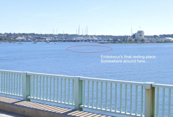
For those of you unfamiliar with this twist in the story, Cook's Endeavour was re-named, sold, then re-hired by the Royal Navy in the 1770s. It happened to be in harbor at Newport, Rhode Island when the British decided to block the harbor. They scuttled a number of low-value vessels including, as it turned out, a vessel named Lord Sandwich, which was the former Endeavour. There's good coverage of all of this with today's updates in the Endeavour Wikipedia article's Final Resting Place section. My best estimate of the location of the bones of Endeavour is here: 41°29'46"N, 71°19'47"W (41.4960, -71.3296). I can see it out my window if I'm in the right corner of my apartment and visibility is good. Visibility is poor today since the snow we got during the blizzard last weekend (about 20 inches with drifts twice that) is melting fast, and it has generated thick fog. I've been listening to vessels sounding their horns all morning as they run through the East Passage of Narragansett Bay.
If you've ever driven to Newport across the Pell-Newport suspension bridge, you have seen the approximate "final resting place" after you cross the main span, just off to your right. I'm attaching a Street View capture of the scene. It's quite close to the bridge and the shore in relatively shallow water. I've marked the likely location with an ellipse. Oh... also... out of frame toward the right, you can see the final resting places of Flight 19 and Earhart's Electra.
Frank Reed
Clockwork Mapping / ReedNavigation.com
Conanicut Island USA


