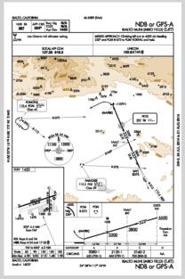
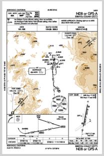
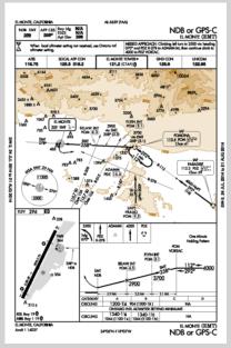
Your question piqued my curiosity since I used to use the ADF and flew many NDB approaches in the past. I got out my book of approach plates for California and went through all of them (and there are literally hundreds and hundreds of instrument approaches in California. There are hundreds of airports here, not all have instrument approaches, but some have many, LAX has 18) and I found that there are only three left in California. Geez, I wouldn't have guessed that because they used to be very common.
Instrument approaches are done when the clouds are so low that you can't see anything outside the plane, you maintain control of the airplane by use of the instruments and guide the plane by use of the radios. An instrument approach gives you a series of courses to follow utilizing the radio guidance and shows the lowest altitude you can descend to on each segment without the chance of bumping into anything. The final approach course brings you to the runway (or just to the airport depending on the type of approach) and descends you to the MDA "minimum descent altitude" and if you can see the runway from there (you must then be below the clouds and have enough visibility to see the runway) you can
descend visually down and land on the runway. If not then you do a "missed approach," start an immediate climb, follow the missed approach courses and then consider whether you should go to your alternate airport.
The standard instrument approach was the ILS, "instrument landing system" which provides very precise guidance both on course and on glideslope to the runway. But the system is very costly and could not be justified at any but the largest airports.
NDBs were a cheap alternative, just one low powered beacon station on, or near, the airport provided course guidance to the airport but no glideslope. Because of the lower precision of this approach, less precise radio signals and possible errors in your compass, the minimums must be higher for this type of approach since they must consider the heights of obstruction in a much larger radius around the airport. But even these cost money to maintain and most have been shut down with GPS approaches replacing them.
It also was very common to have an NDB located about 5 NM out on the ILS final approach course which provided a fix as you passed over it so you knew that it was safe to descend to the MDA. This NDB, also called a "compass locator beacon," also provided guidance to the ILS course from any direction. Since these compass locators were out there they published NDB approaches utilizing these existing facilities as back up for when the ILS wasn't working.
It is very hard to find an airplane anymore that has an ADF installed, they are almost all pulled out and replaced with GPS's.
I have attached the last three NDB approach plates for California (they can also be flown with a GPS). If you look at the chart for the Siskiyou approach you fly to the NDB "MOG" from Klaymath Falls VOR, maintaining at least 10,000 feet altitude, the course is 214 degrees
magnetic and the distance is 42.4 NM. When you get to MOG you turn to 161° magnetic and track outbound for about three minutes, descending to 6,800 feet, and then you turn 45° to the left, fly for about one minute (staying within 10 NM of the station) and then make a 180 turn to the right and fly on a heading of 296°until you intercept the 341 bearing to MOG and then you turn and track it inbound to the station and descend to 4800 feet. Crossing over the station at 4800 feet you turn to 356 and track that bearing outbound from the station and descend to the MDA of 3760 feet above sea level, which is 1112 feet above the airport, you also need a mile and a quarter of visibility. You start timing passing over the station and, based on your estimated ground speed, you figure out how long it will take to get from the station to the airport which is the "missed approach point." The chart shows that at 120 knots it will take 1:21 to the MAP. If you don't
see the airport at that time it is no longer safe to be at that low altitude because you have passed the airport so you climb back up to 6800 feet while making a right turn and fly back to the station and enter the depicted holding pattern (the race track pattern to the east of the station) and consider your options.
gl
From: Francis Upchurch <NoReply_Upchurch@navlist.net>
To: garylapook@pacbell.net
Sent: Thursday, July 31, 2014 7:41 AM
Subject: [NavList] Re: Small craft RDF in 1967
#yiv6509879195 #yiv6509879195 --
#yiv6509879195 {}#yiv6509879195 font-face
{font-family:Helvetica;panose-1:2 11 6 4 2 2 2 2 2 4;}
#yiv6509879195 {}#yiv6509879195 font-face
{panose-1:2 4 5 3 5 4 6 3 2 4;}
#yiv6509879195 {}#yiv6509879195 font-face
{font-family:Calibri;panose-1:2 15 5 2 2 2 4 3 2 4;}
#yiv6509879195 {}#yiv6509879195 font-face
{font-family:Tahoma;panose-1:2 11 6 4 3 5 4 4 2 4;}
#yiv6509879195
#yiv6509879195 p.yiv6509879195MsoNormal, #yiv6509879195 li.yiv6509879195MsoNormal, #yiv6509879195 div.yiv6509879195MsoNormal
{margin:0cm;margin-bottom:.0001pt;font-size:12.0pt;}
#yiv6509879195 a:link, #yiv6509879195 span.yiv6509879195MsoHyperlink
{color:blue;text-decoration:underline;}
#yiv6509879195 a:visited, #yiv6509879195 span.yiv6509879195MsoHyperlinkFollowed
{color:purple;text-decoration:underline;}
#yiv6509879195 p
{margin-right:0cm;margin-left:0cm;font-size:12.0pt;}
#yiv6509879195 p.yiv6509879195MsoAcetate, #yiv6509879195 li.yiv6509879195MsoAcetate, #yiv6509879195 div.yiv6509879195MsoAcetate
{margin:0cm;margin-bottom:.0001pt;font-size:8.0pt;}
#yiv6509879195 p.yiv6509879195msonormal, #yiv6509879195 li.yiv6509879195msonormal, #yiv6509879195 div.yiv6509879195msonormal
{margin-right:0cm;margin-left:0cm;font-size:12.0pt;}
#yiv6509879195 span.yiv6509879195msohyperlink
{}
#yiv6509879195 span.yiv6509879195msohyperlinkfollowed
{}
#yiv6509879195 span.yiv6509879195emailstyle18
{}
#yiv6509879195 p.yiv6509879195msonormal1, #yiv6509879195 li.yiv6509879195msonormal1, #yiv6509879195 div.yiv6509879195msonormal1
{margin:0cm;margin-bottom:.0001pt;font-size:12.0pt;}
#yiv6509879195 span.yiv6509879195msohyperlink1
{color:blue;text-decoration:underline;}
#yiv6509879195 span.yiv6509879195msohyperlinkfollowed1
{color:purple;text-decoration:underline;}
#yiv6509879195 span.yiv6509879195emailstyle181
{color:#1F497D;}
#yiv6509879195 span.yiv6509879195EmailStyle26
{color:#1F497D;}
#yiv6509879195 span.yiv6509879195BalloonTextChar
{}
#yiv6509879195 .yiv6509879195MsoChpDefault
{}
#yiv6509879195 {}#yiv6509879195 page WordSection1
{margin:72.0pt 72.0pt 72.0pt 72.0pt;}
#yiv6509879195 div.yiv6509879195WordSection1
{}
#yiv6509879195 Thanks Gary,
Yes, I found the Scillies NDB on skyvector( which is fantastic), but cannot pick it up from my garden (40miles) will try if I get to sea and get closer! The longest range I’ve picked up is Newquay at 28nm.
Do you pilot guys still use these NDBs for landing and do you think they will continue in service long term?
Could be new lease of life for old RDF units (albeit short range). My frequency range is limited to 250-450 KHz. I’m getting a surprisingly accurate bearing on the Irish radio station(252Khz) 204 nm distant, but cannot find any other
stations broadcasting in long wave. A 3 bearing fix, RTE, Newquay, Culdrose gave me a fairly small cocked hat for my garden (less than half a mile) and I had forgotten to correct for variation which I will now repeat!
This is like some sort of time warp!
Celnav and ordinary pilotage/visual bearings etc are more accurate, but this re-discovered RDF, although hardly “traditional navigation method” is quite good fun. In the 80s, used to do Brittany and Ireland with this and dead reckoning only. (got lost quite a bit in those days!) Went to Decca before i got into sextants/celnav/Bygraves etc.
Any more information on these NDBs would be helpful.
Best
wishes
Francis
From: NavList@navlist.net [mailto:NavList@navlist.net] On Behalf Of Gary LaPook
Sent: 31 July 2014 06:26
To: francisupchurch---.com
Subject: [NavList] Re: Small craft RDF in 1967
That's a really cool website for us pilots. I noticed the NDB, Scilly Iles/St. Mary's, freq 321, ident, STM.
From: Francis Upchurch <NoReply_Upchurch@navlist.net>
To: garylapook---.net
Sent: Wednesday, July 30, 2014 5:36 PM
Subject: [NavList] Re: Small craft
RDF in 1967
That is brilliant. Just found 2 airports NDB ,Newquay 347Khz, bearing 230deg, distance 28nm, Culdrose Naval base 370KHz, 11nm, bearing350deg. Just did a triple fix including the RTE Irish radio 1 252Khz, bearing 350 deg, distance 204nm. Gave my garden correct within about half a mile. I’m amazed. Cant remember it being that accurate using marine bearings in the 80’s but perhaps it was!
Looks like I could use this as another back-up get home system!
My copy and paste didn't work.
Zoom in almost anywhere in the USA and a beacon with morse code identifier will show up.


